Route Editor

| Guide | ♦ | 5 Triplogs | 0 Topics |
details | drive | no permit | forecast | route |
stats |
photos | triplogs | topics | location |
| 50 | 5 | 0 |
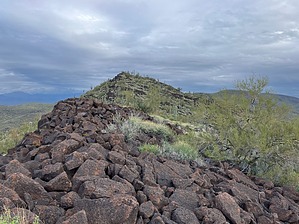
Bag yet another Black Mountain summit! by John10s  Overview OverviewBlack Mountain, which gets its name from the dark volcanic rock in the area, is located on the east side of Lake Pleasant and can be accessed with a round-trip hike of around three miles. The main obstacles you'll encounter on the way to the peak are the rocky terrain and plentiful cacti. Although there are several higher peaks a few miles to the northeast, Black Mountain offers panoramic views of the lake and surrounding mountains. Hike Start the hike near the intersection of Old 87th Avenue and W. Saddle Mountain Road. Saddle Mountain Road is a wide dirt road popular with ATVs, so there's plenty of space to park there, and there's also space on the shoulder of Old 87th. Black Mountain is visible from the parking area, which makes route finding very easy. Start hiking northeast across the open desert, choosing the path of least resistance across the rocky terrain.
After the steep initial climb, the route flattens out a bit along a ridgeline that runs north/south, but the terrain remains rocky throughout. Continue navigating over and around the boulders and cacti until you reach the summit cairn, which can be hard to find among the natural rock piles. Inside is a Barbara Lilley summit register, placed in 2010. Based on the limited number of entries since then, the peak doesn't appear to get many visitors. The register lists the peak's elevation at 2,490', though the HAZ topo marks that elevation farther north on Black Mountain, and a more recent register entry also says the high point is farther north. Those concerned with ensuring they reach the true summit can continue along the ridge to make sure they've stood at the high point. From the top, you'll enjoy beautiful 360° views, most notably of Lake Pleasant directly to the west, though the lake views are partially obscured by Peak 2431. When you're ready to start down, you can return via the same route or consider extending the outing by visiting the Black benchmark on Peak 2431 or hiking several miles northwest of Black Mountain to the Lake Pleasant AT-6 plane crash site. Given the reasonably gentle slopes of Black Mountain, you can descend off the west or north sides for a more direct route to these destinations, and with a loop of ~10 miles, you could visit Black Mountain, the crash site, and Peak 2431 in the same outing. Check out the Official Route and Triplogs. Leave No Trace and +Add a Triplog after your hike to support this local community. | ||||||||||||||||||||||||||||||||||||||||||||||||||||||||||||||||||||||||||||||