Route Editor

| Guide | ♦ | 2 Triplogs | 0 Topics |
details | drive | permit | forecast | route |
stats |
photos | triplogs | topics | location |
| 40 | 2 | 0 |
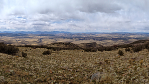
Remote Adventure by chumley   Overview: This remote peak is tougher to get to than it is to climb. But the views are rewarding, and there's virtually no sign of civilization in any direction. Overview: This remote peak is tougher to get to than it is to climb. But the views are rewarding, and there's virtually no sign of civilization in any direction.Private Property Warning: Driving to the start of this hike requires you to cross numerous parcels of private land as well as State Trust Land. As of this writing, the private land was operated by Wagon Bow Ranch, which allows recreational access through an agreement with AZGFD. This access can be revoked at any time. Please follow the rules, respect landowner rights, and sign in at the Kiosk (details in the directions below). The hike itself begins on State Trust Land, but quickly crosses a barbed wire fence that marks the boundary of the ORO Ranch. Permission to access ORO Ranch property must be obtained from the ranch. Getting permission is a difficult task as this ranch does not allow public access. Research from online hunting forums indicates that the ORO Ranch aggressively patrols its borders with armed horsemen. I would not recommend this hike if you do not have permission to cross ORO Ranch Property! Contact information can be easily found via web search.
Hike: The hike begins in the open range just beyond Little Mesa Tank. Head east, crossing what was apparently once an old airstrip. If you look for it, you'll see it! After just 1/4 of a mile, you will cross the fence line that marks the entry onto ORO Ranch property. There are no signs indicating it, but you've been warned. It's private and access is not allowed without permission. Next, follow the javelina trails down into the drainage ahead of you, before climbing up the other side to the visible dirt road. The road will then lead down into Dividing Canyon, across the drainage, and then along a slow but steady climb up the north side of the canyon. Once out of the canyon, follow the road for another mile until reaching the very large Goldwater Tank on your left at about the 2.5-mile mark. A few hundred yards after passing the tank, leave the old road and head left, following obvious cattle tracks up toward the ridge. The cattle have worn paths better than the Boy Scouts, and ascending the ridge is straightforward. At about 4.2 miles, the route switchbacks through a rock outcropping in a section of trail that must certainly have received human assistance. The climb continues steadily before reaching a false peak at the 5.5-mile mark. From here, you will once again have a good view of the peak and its sloped approach. You will head to the right here and cross the saddle before making the final ascent. This portion of the hike no longer has any cattle tracks and you are on your own to pick a route, but the vegetation is forgiving and a route is not difficult to come by. Avoid the desire to head for the large rock outcropping on the right, stay left and cross an open meadow instead. On the ridge, turn right and travel the final 100 yards to gain the peak by staying low on the east side. At the summit, enjoy landmarks in all directions, including the San Francisco Peaks, Granite Mountain, the Bagdad mines, Tres Alamos, the nearby Aquarius range, and the Harquahalas. The descent will be easier to follow the cattle paths, and you can make good time back to the trailhead. Prominence: Mohon Peak is number 64 on the list of 73 of Arizona's Prominent Peaks (2000 feet or more of prominence). This one squeezes in with 2059 feet, with a peak elevation of 7499. Getting There: Detailed driving directions are provided below. The first 15.3 miles on Trout Creek Rd and Bogles Ranch Rd are sedan accessible, 2-lane, graded dirt. The next 3 miles on Wagon Bow Road, Wagon Bow Trail, Torok, and Great Western are 2wd high-clearance accessible in dry weather. The final 4.5 miles are 4wd only with two very rough sections when crossing Winslow and Gonzales Canyons. These roads may deteriorate over time and become impassable, but at the time of this writing, a stock 4wd truck could make the trip. Good tires are recommended. Be prepared, you are miles from anywhere! A GPS track has been posted for the drive as well as the hike. Check out the Official Route and Triplogs. Leave No Trace and +Add a Triplog after your hike to support this local community. | |||||||||||||||||||||||||||||||||||||||||||||||||||||||||||||||||||||||||||||||||||||