 Route Editor

| Guide | ♦ | 1 Triplog | 0 Topics |
details | drive | no permit | forecast | route |
stats |
photos | triplog | topics | location |
| 43 | 1 | 0 |
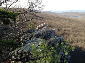
Rockin' the Rocks by kingsnake History: The two segments south of this hike -- this and this -- were the site of the Battle of South Mountain on September 14, 1862, during the Antietam Campaign. But this segment saw no battles. There is a sign just north of Black Rock Creek, indicating the former location of the "Historic Black Rock Hotel", where a 19th century road crossed South Mountain. I did not notice any road/hotel ruins there, but then I did not look for them.
Camping: There are designated camping spots at Annapolis Rocks and Black Rock Creek. Both sites have a privy. Hike: If you start from Boonsboro Mountain Rd. proceed through some guy's back yard, then on a foot bridge across I-70. After the bridge, turn left. In about 100 yards you will meet the trail (to your right) from the designated parking spot. (If you parked there, proceed west about 200 yards to the A.T.) The trail will pass under US-40 / National Pike. 0.3 mi.: The trail bends right and begins the only real climb of the hike, about 400 AEG or rocky surface. (Though the 9.5 mile hike's 1600 AEG is due to the rolling nature of the trail.) At the top of the climb, just to your right, is Pine Knob. As elsewhere along South Mountain, off trail is a tangle of rocks and dead fall. The least ankle-breaky approach to Pine Knob is from the northwest, or just past it on the trail. After exploring Pine Knob, continue north along the wide, smooth, well-groomed trail. 2.5 mi.: Turn left/west towards Annapolis Rocks, which are a quarter mile down slope. There is a privy along the way. The rocks offer a great view west towards Washington County and Hagerstown, and southwest towards Greenbrier State Park. It would not be difficult to climb down the rocks to the base of South Mountain. After exploring Annapolis Rocks, return to the A.T., continuing north. 3.8 mi.: You will see a white sign, high in a tree to your left. There are some neat rocks to explore there. I thought at first it was Black Rock, but it isn't. (Unless it is the very southern edge of Black Rock.) From there, you can work your way off trail (it would not be hard), north 200 yards to Black Rock proper, or do as I did, returning to the A.T., continuing until I saw the official Black Rock sign. Black Rock offers panoramic views from Virginia, through Washington County / Hagerstown, north to Pennsylvania. Like Annapolis Rock, it would be not be too hard to clamber down Black Rock to the base of South Mountain. After exploring, continue north on the A.T. 4.5 mi.: Black Rock Creek has good flow. The source is about .6 miles southeast, up the wash. (The whole of this hike follows the South Mountain ridge, but is anywhere from 100-300 feet downslope from the crest, sometimes on the east slope, sometimes the west.) Just after the crossing an underground spring contributes to the flow. A few hundred yards on is a heavily populated camping area, with a privy and a spring box, which also feeds into Black Rock Creek. A few hundred yards past that is the "Historic Black Rock Hotel". 5.3 mi.: Black Rock Gap, marked by the first double white blaze tree markings that I noticed. (A white blaze indicates the Appalachian Trail; a double blaze, a bend in the trail 6.5 mi.: About 2/3s of the way into the hike, the trail will turn extremely rocky. My pace halved, taking me an hour to go the next 1.5 miles. 8.0 mi.: The trail surface mostly returns to it's normal smooth state, allowing you to pickup your pace without risk of sprains or fractures. 8.8 mi.: The final "climb" is a steep, rocky, bit of a couple hundred yards. After that you will descend 500 feet in a little less than a half mile, along more smooth trail, to Wolfsville Rd. Once you reach the road, turn right/east, about 200 yards up the road to the designated parking spot for your pickup. Check out the Official Route and Triplog. Leave No Trace and +Add a Triplog after your hike to support this local community. One-Way Notice This hike is listed as One-Way. When hiking several trails on a single "hike", log it with a generic name that describes the hike. Then link the trails traveled, check out the example. | |||||||||||||||||||||||||||||||||||||||||||||||||||||||||||||||||||||||||||||||||


