Route Editor

| Guide | ♦ | 1 Triplog | 0 Topics |
details | drive | no permit | forecast | 🔥 route |
stats |
photos | triplog | topics | location |
| 47 | 1 | 0 |
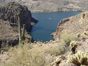
Canyon Lake views galore! by CannondaleKid  Overview OverviewAll off-trail hike that provides a myriad of options for numerous views on the Salt River and Canyon Lake. Warning A high clearance 4x4 is required to reach the trailhead.
Being completely off-trail the route is what you choose to make it. The official GPS track takes the high road along the ridge and returns along a more direct lower route. The hike mileage and AEG are if you take the route provided, however with so much to see you will easily add distance and elevation gain to the total. From the trailhead (3/4 mile south of Brownie Tank past the end of FR1829) you head southeast, passing through a gap in the fence and immediately dropping down into the ravine between Peak 2074 & 2084. Whether you can locate a seldom-used path on the right side or not, one way or another your task is simply to follow the drainage to cottonwood Creek. Based on how much boulder-hopping is entailed, I'd recommend following the 'return' leg of the official GPS track both ways, as it is slightly shorter and less taxing, which is most noticeable on the return leg. Once at the wide Cottonwood Creek wash just continue across to the southeast and either follow the wash as it winds constantly, climbs up to the right to follow the ridge, or climb slightly left and take the more direct route, albeit with a more of an over hill & dale type of route. If you have a GPS with the summit waypoint marked, just set it to navigate to it, then simply vary your route as you see fit while working your way to the summit. I'd recommend the ridge route which provides many more viewpoints of note. Once at the summit, be prepared to spend lots of time wandering around to locate the most interesting views. At 105° it was too hot for me, so be sure to visit when it's cool enough to spend a full day. For the return trip, you can practically see the trailhead in the distance so it's completely up to you which route you choose. Water Sources From time to time there will be some water flow but it cannot be relied on. Even when Cottonwood Creek is flowing farther up the wash, much of it goes underground where you will cross it. Camping Possible but not likely. If anything, possibly camping near Cottonwood Creek by boat from the Salt River. Check out the Official Route and Triplog. Leave No Trace and +Add a Triplog after your hike to support this local community. | |||||||||||||||||||||||||||||||||||||||||||||||||||||||||||||||||||||||||||||||||||||||||||||||||||||