 Route Editor

| Guide | ♦ | 13 Triplogs | 0 Topics |
details | drive | permit | forecast | 🔥 route |
stats |
photos | triplogs | topics | location |
| 191 | 13 | 0 |
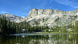
So beautiful you forget how to count! by chumley This high-country trail leads to the spectacularly scenic Ten Lakes in Yosemite National Park. This is one of the most popular hikes in the park away from Yosemite Valley. It is frequented by last-minute backpackers who find that overnight permits are often available at the Wilderness Center when other hikes beginning in Yosemite Valley or Tuolumne Meadows are not available. Permit Information Day-hiking to Ten Lakes is permitted without a permit. Overnight use requires a Wilderness Permit issued by Yosemite National Park. Permits can be reserved 24 weeks before your trip, but some last-minute permits may be available from the Wilderness Center. See permits for more information. There are 40 permits available from this trailhead each day--more than any other in the entire park! The destination offers dozens of places to camp so that solitude can be easily found. But you should also expect to encounter a few other backpackers while in this area.
The hike begins across the road from the Yosemite Creek Trailhead on the Tioga Road about an hour from Yosemite Valley. There are restrooms and bear boxes at the trailhead. Shortly after beginning the hike you encounter the trail junction that leads down-canyon to Yosemite Falls and Yosemite Valley via Yosemite Creek. Turn right at the junction and head uphill. The first half mile of trail follows a lightly wooded area before entering more exposed granite terrain for a mile or so. The trail is occasionally difficult to follow on the open granite, but if you keep an eye out for cairns and generally stay on the high side, you will be on route. At 2.1 miles you reach a signed trail junction indicating White Wolf 5.5 miles to the west. The trail also crosses a small creek here before shifting to a steeper climb through nicely shaded pine forest. The footing along this stretch is a very pleasant soft dirt. The trail crosses another creek at 3.4 miles before cresting a small summit and entering the beautiful Halfmoon Meadow at 4.0 miles. The trail skirts the northwest side of the meadow before beginning a steep, switchback-filled ascent that climbs about 600 feet in half a mile. When you think you've reached the top, the trail turns to the right and climbs a bit more through some rocky terrain to the the trail junction for Grant Lakes at 4.8 miles and the summit of Ten Lakes Pass at the 5.0 mile mark. The crest of 9,686-foot Ten Lakes Pass offers some stunning views over the majestic Sierra Nevada and the northern reaches of Yosemite National Park. The trail begins to drop off the pass before the first of the lakes comes into view, followed shortly by a second. As you switchback down toward the lakes, a view down to the Grand Canyon of the Tuolumne River appears on the left. Once at the bottom, most people will camp along the nearest shore of the first lake. But there are ample alternate campsites to choose from. Don't be afraid to hike a bit farther. Each of the lakes offers different views and perspectives, with creeks and cascades flowing between them. The marked/maintained trail continues to the east, and can be used to connect other great backpacking destinations including High Sierra Camps at May Lake and Glen Aulin, or to trailheads at Tenaya Lake and Tuolumne Meadow. There are unmaintained use paths to all the lakes and these make for great day trips or exploring while you are in the Ten Lakes area. Camping Yosemite regulations require you to camp at least 100 feet from the lake shore, and 100 feet from a trail. If you wish to have a fire, you must use an existing fire ring. Bears are prevalent throughout Yosemite National Park, and the use of a bear-resistant canister for food (and all items with a scent) is required by federal law. These rules are explained when you get your permit, but it is worth noting here since this is a popular area.
Check out the Official Route and Triplogs. Leave No Trace and +Add a Triplog after your hike to support this local community. One-Way Notice This hike is listed as One-Way. When hiking several trails on a single "hike", log it with a generic name that describes the hike. Then link the trails traveled, check out the example. | |||||||||||||||||||||||||||||||||||||||||||||||||||||||||||||||||||||||||||||||||||||||||||||||||||||||||||||||||||||||||||||||||||||||||||||||||||||||||||||||||||||||||||||||||||||||||||||||||||||||||


