A hike through a cool Douglas-fir forest that climbs the west slopes of Elden Mountain to an alpine meadow and a viewpoint overlooking volcanic peaks and the Painted Desert. The trail, which is not shown on the topographic map, starts up a northwest-facing canyon through a cool, dense Douglas-fir and quaking aspen forest. Soon it switchbacks to the left and ascends the slope via several more switchbacks. You’ll have occasional views of the beautiful forest on the north slopes of Elden Mountain. The climb ends abruptly when the trail emerges into Oldham Park, an alpine meadow on the summit ridge of the mountain.
When hiking several trails on a single "hike", log it with a generic name that describes the hike. Then link the trails traveled, check out the example.
WARNING! Hiking and outdoor related sports can be dangerous. Be responsible and prepare for the trip. Study the area you are entering and plan accordingly. Dress for the current and unexpected weather changes. Take plenty of water. Never go alone. Make an itinerary with your plan(s), route(s), destination(s) and expected return time. Give your itinerary to trusted family and/or friends.
Permit $$
no fees or permits reported
if incorrect tell us about it
Directions
Road
To hike From Flagstaff, take US180 West/Fort Valley Road to Shultz Pass Road (2.6 miles). Turn right on Shultz Pass Road, then take the right fork to get onto Elden Lookout Road. The TH is 0.7 miles from the point that the road turns from a paved to a dirt road. There is a small parking area on the left. The trailhead has a small sign that can be seen from the road.
 Route Editor

 A hike through a cool Douglas-fir forest that climbs the west slopes of Elden Mountain to an alpine meadow and a viewpoint overlooking volcanic peaks and the Painted Desert. The trail, which is not shown on the topographic map, starts up a northwest-facing canyon through a cool, dense Douglas-fir and quaking aspen forest. Soon it switchbacks to the left and ascends the slope via several more switchbacks. You’ll have occasional views of the beautiful forest on the north slopes of Elden Mountain. The climb ends abruptly when the trail emerges into Oldham Park, an alpine meadow on the summit ridge of the mountain.
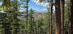


