Route Editor

| Guide | ♦ | 4 Triplogs | 0 Topics |
details | drive | permit | forecast | route |
stats |
photos | triplogs | topics | location |
| 60 | 4 | 0 |
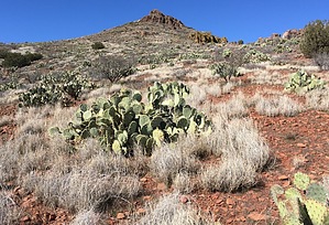
The Perfect Little Leg Stretcher by AZHiker456   Located right off I-17 just a few miles down Dugas Road, this beautiful little summit hike makes for the perfect leg-stretcher. Whether you’re passing by on a long drive, need to let off some steam after suffering through Phoenix rush-hour, or just feel like stopping by to check out the beautiful area, this short hike to Estler Peak will fit the bill. Located right off I-17 just a few miles down Dugas Road, this beautiful little summit hike makes for the perfect leg-stretcher. Whether you’re passing by on a long drive, need to let off some steam after suffering through Phoenix rush-hour, or just feel like stopping by to check out the beautiful area, this short hike to Estler Peak will fit the bill.Despite an AEG of less than 500 feet, the summit views are surprisingly beautiful. And, although only a 1-2 miles round trip, there is no official trail, which always adds to the fun. The surrounding area has been extremely well trampled by cattle, offering a myriad of routes to choose from and a ‘brush-factor’ that is lower than many trails. While there is still some thorny vegetation to watch out for, [a catclaw like shrub and some prickly pear are the worst offenders], the margin for error between the brush is one of the largest I’ve ever seen for a bushwhack. You’d practically have to be blindfolded or take a really bad stumble to come into contact with thorns/brush.
There is a large wooden cross sandwiched between two boulders by the highpoint, as well as a U.S. Geologic Survey Marker. In the place where the peak name is typically listed is the word: SPRING. A quick Google search shed some light on things, revealing that an alternate name for Estler peak is the Spring Benchmark. I was unable to find a summit register. For my return trip, I took a slightly different route. Whenever possible, I almost always opt for loops over out-and-backs, and there are several different loops and options for the short hike to Estler Peak. A final note about routes: I was unable to approach from the nice large parking area where the official HAZ route for this peak takes off from. There were literally about 50 cows, including several babies, right around and in the parking area. After honking my horn and doing a few donuts failed to make them flinch, I decided to head further down Dugas Road, which circled partway around the base of the mountain before heading away from it. Just as Dugas road started to veer away, I noticed a Forest Service Road [9602R] on the right, and almost immediately after turning onto 9602R, there is a small area to park on the left. The moderate ‘hump’ required to access 9602R might present problems for low-clearance vehicles, but a standard high-clearance vehicle will have no trouble. Check out the Official Route and Triplogs. Leave No Trace and +Add a Triplog after your hike to support this local community. | ||||||||||||||||||||||||||||||||||||||||||||||||||||||||||||||||||||||||||||||||||||||||||||