Route Editor

| Guide | ♦ | 43 Triplogs | 0 Topics |
details | drive | no permit | forecast | route |
stats |
photos | triplogs | topics | location |
| 107 | 43 | 0 |
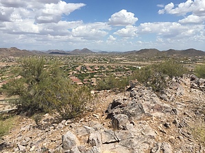
 Hike HikeFollow the Official Route. Nearby Canal History Nov 8th, 1909 - Canal turned on land under the canal. Roughly 9k acres were planted with sugar beets. Vulture Road became Grand Avenue. By 1920 the gamble on sugar beets was bleak as it became apparent the soil could not produce a sweet enough beet. RP Davie sold his holdings to Southwest Cotton Company, a division of Goodyear Tire. Marinette transformed into a cotton farming community.
May 9th, 1926 - Goodyear Rubber Company widened the canal to 14 feet from the Headgates to Marinette. At which time a phoneline was installed from Marinette to Frog Tanks ( Beardsley ). 1934 - resolution of dissolution filed for the canal 1936 - Marinette Ranch was sold to JG Boswell. Cotton production skyrocketed. By means of machines replacing man labor, thus the town dwindled. 1941 - Webb contracted to build Luke Air Field 1959 - Boswell released cotton acres to Webb 1960 - Orders for 400 homes, a shopping center, and a clinic were in place Calderwood Butte area contains Hohokam archaeological sites. Check out the Official Route and Triplogs. Leave No Trace and +Add a Triplog after your hike to support this local community. | ||||||||||||||||||||||||||||||||||||||||||||||||||||||||||||||||||||||||||||||||||||||||||||||||||||||||||||||||||||||||||||||||||||||||||||||||||||||||||||||||||||||