 Route Editor

| Guide | ♦ | 11 Triplogs | 0 Topics |
details | drive | no permit | forecast | 🔥 route |
stats |
photos | triplogs | topics | location |
| 182 | 11 | 0 |
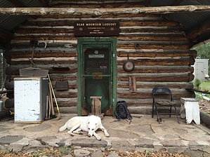
"I came, I saw, I hiked." by FOTG  Overview OverviewSawmill trail is a starting point for reaching several less-traveled Primitive Blue Range East trails culminating at the summit of Bear Mountain. The trail is generally easy to follow with the appearance of trail construction near the bottom. However, as you approach Telephone Ridge Trail, it becomes a little eroded and overgrown in spots. A moderate trail by P.B.R. standards, however, the upper sections may be a little overwhelming for beginners, and some may find the route along Telephone Ridge a little overgrown for their liking. The trail serves as an ideal starting point for the 3000-foot climb to the summit of Bear Mountain or entry into the scenic Largo Canyon, which features a section of trail from Scott Warren's 100 Hikes in Arizona. The more ambitious could use Sawmill Trail as a starting point for longer treks into New Mexico and the Apache and Gila Wilderness areas. Hike The trailhead is well signed and indicates the beginning of the trail. There is an established area for parking with a kiosk and register for signing in. A quick glance at the sign-in sheet indicated that most traffic on this trail comes almost exclusively from hunters. After a quick series of switchback under a nice stand of trees, the trail is generally devoid of shade. However, soon you will be paralleling a small drainage under the canopy of some larger trees. Keep in mind there are probably very few times when water will be available along this trail. You will climb through a nice forested pine area, but the section of the trail to Telephone Ridge is a little underwhelming. There are some nice stands of Ponderosa along this portion of the trail and a few quaint areas with enough redeeming qualities to enjoy a quick break. However, the more scenic sections of this trail are at the higher elevations, the more elevation one gains, the better the views get. Be sure to take a minute and check your six and take in some of the views to the west as you make the final ascent up Telephone Ridge.
From Telephone Ridge your nice views will switch primarily to the east and into New Mexico. After navigating the ridgeline, one has a relatively easy climb to the summit from the intersection of WS Lake Trail #54. The views from Bear Mountain are minimal due to the height of the trees. However, there is enough interesting stuff at the summit to make it a worthy destination. The more adventurous may want to climb the fire tower to increase their viewing pleasure. If looking for some extra miles or in desperate need of water, there is the option of a side trip to Bear Spring, the only reliable water source in the area according to the Forest Service. But remember, it’s a one-way trip, and it will add an additional four-plus miles to your day, and approximately 1500 more feet in elevation gained. Check out the Official Route and Triplogs. Leave No Trace and +Add a Triplog after your hike to support this local community. One-Way Notice This hike is listed as One-Way. When hiking several trails on a single "hike", log it with a generic name that describes the hike. Then link the trails traveled, check out the example. | ||||||||||||||||||||||||||||||||||||||||||||||||||||||||||||||||||||||||||||||||||||||||||||||||||||||||||||||||||||||||||||||||||||||||||||||||||||||||||||||||||||||||||||||||||||||||||||||||||||||||||||||||||||


