Route Editor

| Guide | ♦ | 3 Triplogs | 0 Topics |
details | drive | no permit | forecast | route |
stats |
photos | triplogs | topics | location |
| 48 | 3 | 0 |
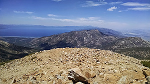
Highest Peak in Tahoe! by Booneman Starting from Horse Meadow, there is a small jeep road that heads West across a stream that you'll want to follow for the first half mile until it turns into single track. Stay to the right and begin climbing a few hundred feet until you reach Armstrong Pass, which will also be the one-mile mark and the TRT intersection. Go right towards the sign indicating Starr Lake. From here the trail veers toward the lake and goes uphill subtly for the next 3.1 miles. A good view of the lake finally becomes visible at this pass, though the landscape and rock formations should hold you over until then. There is a sign indicating you have one mile left to reach the peak, and the toughest section awaits. Continue on until you're standing on the summit, make sure you take a moment or two to look back as the sights just keep getting better the higher you go!
Check out the Official Route and Triplogs. Leave No Trace and +Add a Triplog after your hike to support this local community. | ||||||||||||||||||||||||||||||||||||||||||||||||||||||||||||||||||||||||||||||||||||||||