Route Editor

| Guide | ♦ | 3 Triplogs | 0 Topics |
details | drive | no permit | forecast | 🔥 route |
stats |
photos | triplogs | topics | location |
| 84 | 3 | 0 |
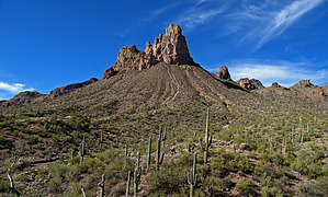
.. A 40 ft Seasonal Waterfall Awaits You .. by Grasshopper  Overview OverviewThis rugged off-trail, thick desert vegetation, true loop hike around Byous Butte with required boulder scrambling & bushwhacking on a side trip into a most remote, unnamed canyon in Hewitt's Ridge that few humans have ever seen offers the intermediate/advanced day hiker that enjoys a true destination pay-off, a real treat: a 40-foot waterfall with seasonal water flow and a large slick rock pool basin area with rugged near and distant canyon views to bring you back again! History This area around and behind towering Byous Butte at 3837ft and just outside the Superstition Wilderness boundary line has some of the healthiest stands of Saguaros in the whole Superstition Wilderness. There was also some very serious geology that took place here eons ago and as such, numerous interesting rock and mineral formations dominate the landscape in this whole area. For the rockhound, hiker like me, this is a real candy store!
This 3.7-mile hiking loop route (see & download my posted GPS Route dated 1/1/09) and ~5 hours required hike (which includes a stop for a lunch break and pictures) is almost completely off-trail except for the first 0.75mi route to what I call Byous Butte- Saddle#1(at GPS waypoints N33 22.161 W111 12.727). Over the past two-year period I have marked this first 0.75mi route with rock cairns (Update Nov'23: These rock cairns no longer exist). Unless you are doing a car shuttle hike (see below driving direction details for more info), the last 0.66mi of this loop hike is on FR172 back to your beginning TH Start location (also see below driving directions for TH Start information). This remote off-trail loop hike with a side trip into a most interesting unnamed canyon in hidden Hewitt's Ridge is visited very seldom by humans and could quite possibly retain some ancient Indian Ruins. Some of my 1/1/09 posted pictures indicate this possibility, but this trip I did not have time to further explore to confirm or deny. Once up to Byous Butte Saddle#1, you will proceed on the saddle over to the Right(north) and then switchback your way into the main Byous Butte drainage below. When arriving in this lower drainage, you will continue following this rocky and overgrown drainage southwest downhill to where it intersects the Byous Butte drainage coming in from the south to northwest, intersecting at approx GPS Waypoints N33 22.038 W111 12.924; You will make your way down into this intersection area (chose your path of least resistance) and then start the hike scramble continuing northwest up this same drainage having to sometimes push your way through dense downfall and overgrowth. DON'T GIVE UP.. take my word for it, your ending destination up canyon is approximately 0.46mi to go (at GPS Waypoints N33 22.160 W111 12.977) is going to be worth all your effort. The last 0.46mi of this spur canyon hike has some wonderful, rugged, and most remote canyon views that only a very few have ever witnessed, and as you continue further toward your ending destination to this "40-foot waterfall area", depending on the month of the year you do this trip, hopefully, you will be rewarded like I was with water starting to flow down the canyon drainage indicating you are getting closer. When you arrive at this previously mentioned GPS ending waypoint and slick rock basin-waterfall area you will know it! Also, don't forget your camera for this one! Your trip back to complete this true loop hike will be to backtrack the 0.46mi to the canyon drainage intersections and then just continue in the canyon south drainage an additional scenic and interesting 1.1mls to intersect FR172 at the Byous Springs area (at GPS Waypoints N33 21.439 W111 12.544). From here, you will either car shuttle or hike the remaining 0.66mi backup FR172 to your beginning TH Start location. Update Nov'23: Due to the present off-trail overgrowth, this above noted route is now the recommended hike route- A shorter "in and out" hike to this remote Hewitt Ridge Canyon 40ft waterfall area, then you would start hiking north up the Byous Butte drainage from the Byous Springs area (TH) then just return the way you went in. Check out the Official Route and Triplogs. Note This is a moderately difficult hike. Leave No Trace and +Add a Triplog after your hike to support this local community. | |||||||||||||||||||||||||||||||||||||||||||||||||||||||||||||||||||||||||||||||||||||||||||||||||||||||||||||