 Route Editor

| Guide | ♦ | 11 Triplogs | 0 Topics |
details | drive | no permit | forecast | map |
stats |
photos | triplogs | topics | location |
| 61 | 11 | 0 |
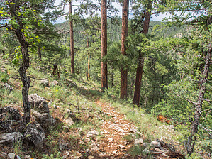
  NOTE NOTEFor the more popular west trailhead for Kinder Crossing Trail #19 please see this page. The east access described here is much more difficult to get to and leads to the same destination, just from the other side of East Clear Creek canyon. The east trailhead begins at the end of Forest Road 9723S. It heads quickly and steadily down toward East Clear Creek on a rocky, but easy-to-follow 1/2 mile of trail that is cut just below the ridge. At the bottom, the trail turns to the left and follows the east bank of the creek for 3/4 mile to the crossing just above a cascade and two pools. You can head back the way you came, or continue the crossing on the west side of the canyon as described in the official description for Kinder Crossing Trail #19.
Check out the Triplogs. Leave No Trace and +Add a Triplog after your hike to support this local community. One-Way Notice This hike is listed as One-Way. When hiking several trails on a single "hike", log it with a generic name that describes the hike. Then link the trails traveled, check out the example. | |||||||||||||||||||||||||||||||||||||||||||||||||||||||||||||||||||||||||||||||||||||||||||||||||||||||||||||||||||||||||||||||||||||||||||||||||||||||||||||||||||||||||


