Route Editor

| Guide | ♦ | 1 Triplog | 0 Topics |
details | drive | no permit | forecast | route |
stats |
photos | triplog | topics | location |
| 14 | 1 | 0 |
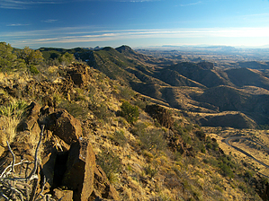
you can't lose in the Big Lues by PrestonSands   Overview OverviewThis off-trail hike follows a ridge to the top of a nameless mountain, which forms the western edge of the Big Lue Mountains, near the Arizona-New Mexico border. Although nameless, I refer to it as Mule Mountain due to the word "Mule" stamped into the summit's bronze survey marker. The attractions of this hike are the unequaled views of eastern Arizona and the massive Mogollon Mountains of New Mexico's Gila Wilderness. Route finding ability and a topographical map are recommended for this hike. The hike described here begins along Highway 78 at the Blackjack Campground, which serves as a convenient parking area, and is mile 0.0 for this description.
From the Blackjack Campground entrance, walk south on the highway (back towards Safford) for about 0.2 miles to a 30 mph sign on your right. Just past the sign, a dirt side road drops off the highway to your right, next to a large dirt pile (shown as a gravel pit on the Big Lue Mountains topographical map). Follow this side road for about 200 feet, and a second dirt road will appear on the right (33.05564 N, 109.08193 W), heading uphill. Follow this second road (a former highway alignment that parallels the current highway) for a quarter of a mile or so to its end at a rocky area overlooking highway 78. There is a cairn here (33.05375 N, 109.08525 W), marking the beginning of the ridge route. Begin bushwhacking up the crest of the broad ridge from the cairn. A couple of hundred feet up, the dense vegetation gives way to killer views of ultra-rugged Black Jack Canyon below, as the ridge narrows and turns to exposed bedrock. To the south, a complex series of evergreen ridges surround flat-topped Maverick Hill, which forms the highpoint of the area. The return route on this stretch offers a continuous view of the majestic Mogollon Mountains to the east. At around 1.2 miles, the ridge ends at a small rounded hill (33.05249 N, 109.09328 W) which forms the southernmost edge of Mule Mountain. The route turns northwest at this point to climb along the mountain's edge. Tall grasses hide a sea of ankle-twisting basalt rocks as the route climbs into juniper woodland. After 1.5 miles, the hike reaches the 7047-foot summit (33.05528 N, 109.09611) of Mule Mountain, where several circular bronze survey markers grace the bedrock at the edge of the precipice. There are views in all directions here, the most commanding of which is to the west, where highway 78 forms an absurd series of loops, some 1500 feet below. Be sure to sign the register. One can return via the same route (which is the easiest and most scenic), or bushwhack almost anywhere off the eastern side of Mule Mountain to reach highway 78. Check out the Official Route and Triplog. Leave No Trace and +Add a Triplog after your hike to support this local community. | ||||||||||||||||||||||||||||||||||||||||||||||||||||||||||||||||||||||||||||||||||||||||