Route Editor

| Guide | ♦ | 68 Triplogs | 0 Topics |
details | drive | no permit | forecast | route |
stats |
photos | triplogs | topics | location |
| 322 | 68 | 0 |
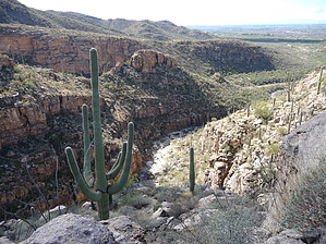
Canyon Loop with Great Views by Red Rover  Overview OverviewWe've been talking about trying to find the trail up one side and down the other of La Milagrosa Canyon and Agua Caliente Canyon east of Tucson for some time. We finally took off to do it on a beautiful January day, and the search was worth it. Hike Start east on Horsehead Road, which is blocked by a gate that was open the day we arrived (see Directions below.) As you walk down this dirt road, it turns to a paved road after about half a mile for about 200 yards. When Horsehead Road intersects Wentworth Road, you'll see a 4WD dirt road blocked by a gate. The fence beside it was crushed so you could walk over it, but if you have to open the gate, be sure to close it after you. Continue along this road, which crosses Molino Wash and contours around a low ridge. The La Milagrosa Ridge trail goes off to the left. You'll soon pass a side trail to the left that goes to a small, abandoned house. If you take this trail, look for the main trail below the house, or backtrack to where you turned off. To your right is the wash that comes out of Agua Caliente Canyon, but wait to explore it when you come back this way as you complete the loop.
The trail will seem to end with a drop-off straight ahead but look for it to your left to climb the small hill. After continuing over the hill, you'll drop down to your right and cross a drainage. Even on a day with water in other areas, this was mostly dry, but you could see that it would be a funnel for water in heavy rain. After you cross this drainage, look for the trail to climb the hill in front of you and back toward La Milagrosa on your right. When you come to a "Y" in the trail, take the right fork. The left trail continues to Molina Basin on the Catalina Highway. The right fork soon starts a descent to the bottom of the canyon. You can look across the canyon at the trail you'll take up the other side. As you enter the canyon floor, you may find pools of water and even a small beach, depending on the time of the year. It was lovely in January. Turn right (west) toward Tucson on the floor of the canyon for a few hundred yards. Look for cairns to locate the trail as you wander along while watching for the trail leaving the canyon bottom and climbing up the opposite side. Even though we did some "exploring," it wasn't hard to find the trail. The climb up the canyon's opposite side seems long as you travel up a mostly dry grass and dirt trail that even turns back east briefly. But keep going until you come to a "Y" in the trail. Take the right fork that allows you to cross a relatively flat area at the end of the ridge. As you look ahead, it's easy to spot the trail winding through the saguaros. There are few opportunities to look off the ridge into Agua Caliente Canyon on this side. The canyons are blocked from view unless you bushwhack through some rough terrain with plenty of shin daggers. Straight ahead is Tucson as you travel mostly west and gradually start down the ridge. You'll come to another gate and fence as you near the end of the ridge. The trail gets quite rocky and is a series of switchbacks until you reach the wash again. As you reach the lowest area, you'll come out at a pool in the wash below the abandoned house you saw when you started. After crossing the wash, climb the hill to rejoin the trail you started on. Turn left (west) on the trail toward the gate near Wentworth, and travel back down the paved/dirt road to your car. It's a great hike with elevation change up and down four times and great views of canyons, pools, and Tucson in the distance. There is little to no shade, so this is a very early summer hike, if at all. Winter is great. Gate Policy: If a gate is closed upon arrival, leave it closed after you go through. If it is open, leave it open. Leaving a closed gate open may put cattle in danger. Closing an open gate may cut them off from water. Please be respectful, leave gates as found. The exception is signage on the gate directing you otherwise. Check out the Official Route and Triplogs. Leave No Trace and +Add a Triplog after your hike to support this local community. | ||||||||||||||||||||||||||||||||||||||||||||||||||||||||||||||||||||||||||||||||||||||||||||||||||||||||||||||||||||||||||||||||||||||||||||||||||||||||||||||||||||||||||||||||||||||