Route Editor

| Guide | ♦ | 8 Triplogs | 0 Topics |
details | drive | permit | forecast | route |
stats |
photos | triplogs | topics | location |
| 293 | 8 | 0 |
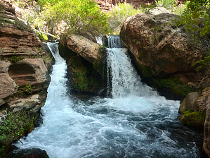
Go prepared! - Caving Checklist A River Runs Through It by chumley   Overview OverviewTapeats Creek flows from a spring at the base of the Redwall in the drainage between Monument and Crazy Jug Points. Reaching the spring requires a wet hike up Tapeats Creek followed by the steep, off-trail ascent of Tapeats Spring Canyon crossing the rough terrain of several massive landslides. Just west of the spring is Tapeats Cave, created by the waters that flow from the spring. Water Flow Warning This hike requires at least a dozen creek crossings. During normal water flow, this should be possible for most healthy adults. The water flow is approximately 75cfs and about thigh deep at crossing points. However, during times of higher flow (primarily spring snowmelt and summer thunderstorms) negotiating the creek crossings may be impossible.
This hike is entirely off-trail. Parts include water crossings, in-creek hiking, looking for use trails, short class-3 climbs, and very steep slopes with loose footing. Only hikers experienced with off-trail hiking in the Grand Canyon or other extreme desert environments should attempt this trip. Cave Entry Restrictions Grand Canyon National Park Back Country Use Regulations state the following: "Because of their sensitive and sometimes dangerous nature, entry and/or exploration of any caves or mines must be approved in advance through Grand Canyon N.P." If you wish to enter the cave, contact the BCO about entering this cave when you apply for your backcountry permit. Hike Part 1 -- Tapeats Creek Begin the hike at the designated AW7 campsite (Upper Tapeats) and proceed upstream about 300 yards to the confluence where Thunder River flows into Tapeats. Cross the creek just below the confluence and follow the use path upstream on the east side. At about .25 miles you will pass a possible camping area before being forced to cross to the north side of the creek and passing another potential campsite sheltered under some cliffs. Continue upstream following cairns and use paths, crossing the creek when necessary. At 0.9 miles you reach a beautiful narrow curve somewhat reminiscent of "The Subway" in Zion NP. You'll have to cross the creek here too. At 1.1 miles you will enter a boxed in slot that requires you to hike in the stream for 100-feet. At 1.2 miles you will reach a larger fall that is your mark to exit to the right (south) and climb up onto the bench to cut a corner. Getting up onto the shelf can be done via a cairned route and a narrow stepped ledge that rises about 15 feet. Alternately, you can cross to the north side of the creek and go upstream about 50 feet before crossing back to the south side and ascending via an easier route with no climbing. The next quarter-mile takes you across the bench before dropping back to creek level. At 1.6 miles you need to climb over a large landslide of sharp boulders followed immediately by a nice large camping area on the south bench. This is just a hundred yards downstream from where the stream turns to the north and ascends Tapeats Spring Canyon. Hike Part 2 -- Tapeats Spring Canyon At the 1.65 mile mark, turn to the north and begin to climb Tapeats Spring Canyon on the east side of the Creek. At 1.75 miles you will see a beautiful 40-foot waterfall. Ascend to the right of the falls and cross the creek above the falls. Immediately climb up the rockslide consisting of house-sized boulders and descend the other side. Follow the left side of the creek until you dead-end at split waterfall at 2.1 miles. Make your last creek crossing below the falls, and continue to hike upstream on the east side. From here on up the route becomes increasingly steep and difficult as it leaves the creek at 2.25 miles and traverses the numerous landslides that line the canyon. The views up canyon are great, and the mature cottonwoods provide a visual target of your destination all while the sound of the raging creek never dissipates. But these final .75 miles are excruciatingly slow and challenging. The last 200 yards climbs a steep slope of large boulders. At the 3.0 mile mark at the top of the boulder field, you will see the entrance to the cave on your right. The top of the springs are just through the brush to the west, and the flow comes from numerous different cracks, crevices, and seeps in the area. Explore the cave only if you have NPS permission and are prepared. The hike back down retraces the way you came. The descent is quicker, but by no means fast. The terrain doesn't allow for it. Geology/History Similar to the nearby Thunder River Cave, the waters that feed Tapeats Creek emanate from an underground river trapped by the impermeable area where the Muav limestone meets the Bright Angel Shale. The cave is formed along a visible fault and carved out of the Muav limestone. The massive landslides in this part of the canyon likely occurred at about the same time, 750,000 years ago, when rising waters behind lava dams downstream saturated the Bright Angel Shale, causing it to significantly weaken and collapse under the weight of the rock above it. The climb up Tapeats Spring Canyon crosses several of these massive landslides. The source of Tapeats Spring does not come out of a nice cave-like Thunder River because a landslide impeded the flow with debris. Statistics Tapeats Spring is the highest flowing spring on the North Rim. At 48 million gallons per day, it releases more than twice as much water as nearby Thunder River or Roaring Springs. Camping All camping requires a backcountry permit obtainable from the Grand Canyon Backcountry Office. The nearest designated campsite is at Upper Tapeats Creek (use area AW7). Check out the Official Route and Triplogs. Note This is a moderately difficult hike. Leave No Trace and +Add a Triplog after your hike to support this local community. | |||||||||||||||||||||||||||||||||||||||||||||||||||||||||||||||||||||||||||||||||||||