 Route Editor

| Guide | ♦ | 26 Triplogs | 2 Topics |
details | drive | permit | forecast | route |
stats |
photos | triplogs | topics | location |
| 239 | 26 | 2 |
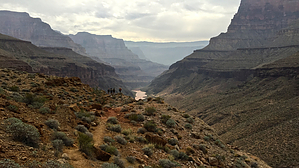
River Walk by chumley  Overview OverviewThis is a regularly used route that connects Deer Creek Camp (AX7) with Lower Tapeats Creek (AW8). It is not a maintained trail and involves scrambling, short climbs, and loose footing on steep rocky slopes. This guide explains the route from west to east but can just as easily be traveled from Tapeats to Deer Creek.
The hike begins by crossing to the east side of Deer Creek just above the "Patio". Cairns mark the well-worn route up a steady 300-foot ascent to a saddle in the first .025 miles. The next 0.25 miles descends 200 feet before crossing a drainage and leveling out. (Along the way, you pass a cairned junction for a more precarious route that parallels this route a couple of hundred feet lower along cliffs just above the river.) The next 1.25 miles is a reasonably steady traverse with expansive views of the canyon while making its way around a couple of small drainages before dropping steeply back to the river at the 2-mile mark. (This is also where the lower route re-joins this route). The remaining 1.25 miles of the route crosses various terrain: deep sand, river rock, and typical inner-canyon rocky terrain. At the 2.75 mile mark, the route passes Bonita Creek and requires a steep climb up a loose slope. Shortly before arriving at the mouth of Tapeats Creek, you pass an open campsite (AM9) along the Colorado River before reaching the designated camp at Lower Tapeats (AW8). East of the creek is a boat beach where rafters often park for day hikes to Thunder River. Camping All overnight use in Grand Canyon National Park requires a permit obtainable from the Backcountry Office. Designated camps are available at both ends of this route, and dispersed camping permits are available along the river. Rafters may day-hike this route without an additional permit. Check out the Official Route and Triplogs. Leave No Trace and +Add a Triplog after your hike to support this local community. One-Way Notice This hike is listed as One-Way. When hiking several trails on a single "hike", log it with a generic name that describes the hike. Then link the trails traveled, check out the example. | |||||||||||||||||||||||||||||||||||||||||||||||||||||||||||||||||||||||||||||||||||||||||||||||||||||||||||||||||||||||||||||||||||||||||||||||||||||||||||||||||||||||||||||||||||||||||||


