Route Editor

| Guide | ♦ | 2 Triplogs | 1 Topic |
details | drive | permit | forecast | map |
stats |
photos | triplogs | topic | location |
| 37 | 2 | 1 |
Canyons are inherently risky. Flash floods occur without notice on sunny days. Technical skills & surrounding topography knowledge required yet does not eliminate risk.
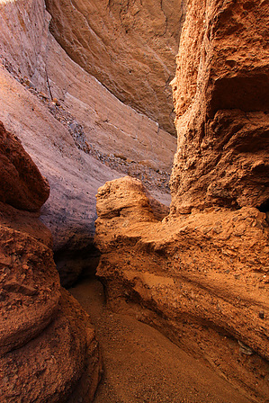
Slots of Fun by RickVincent  Overview OverviewThis normally dry wash boxes up within 1/2 mile from the start. Hike the main drainage or let your curiosity draw you into the maze of side canyons and slots. Warning Like all slot/box canyons, this canyon is susceptible to flash flooding. Be aware of upstream weather conditions before visiting the area.
The hike begins in the Turkey Creek wash heading south (upstream). At about 1/3 mile the wash forks. Stay to the right. About 1/2 mile in the wash starts to box up. Not a very deep slot at this point, but narrow (less than 10 feet wide). Keep an eye out to your left. At about 2/3 mile, the first slot on the left comes into view. This side slot is about 1/3 mile long. It is narrow at times (shoulder-width). The bottom is sandy and flat. There are a few upclimbs over boulders that are fairly easy to navigate. Some of the boulder obstacles can be passed by going under or over. The slot opens up for a while then closes back up again. It finally opens up for the last time and becomes less interesting. This is a good place to turn around. The next side canyon is only 1/3 mile upstream from the mouth of the first slot. This canyon doesn't slot up quite as much until you make your way deeper into it. It finally slots up as you approach a massive alcove with a huge roof. Would seem like a great place to stay out of the rain, except that you are in a slot canyon subject to flash flooding. Higher ground would be suggested in inclement weather. The canyon opens up and becomes less interesting after the alcove. There may be more goodies to discover further upstream, but this is as far as I went on this trip. Turn around and head back to the main drainage. Continue upstream down Turkey Creek for another 1/2 mile of narrows. The wash opens up beyond this point and soon looks like a typical dry desert wash. This is a good place to turn around. On your way back, be on the lookout for a couple of side canyons that look more like slides or chutes dropping into the main drainage. We explored one of these. The rock is nice and grippy for climbing, but there is some exposure, so be careful. Assuming you hit both side canyons mentioned above, but skipped the chutes or any other side ventures, you will have hiked about 4 miles to your return location. The hike is easy, but be sure to set aside plenty of time for exploring. This is an interesting area. Don't rush. Camping Options exist all along Turkey Creek. Again, be aware of weather conditions upstream if you plan on camping near the creek bed. Northward travel (downstream) appears to lead to denser vegetation (sycamore, cottonwood, etc). May be more appealing camp spots downstream. BLM land exists further downstream towards Oak Grove Canyon. Permits According to azaccessmap.com, this area appears to be on State Trust Land which would mean a use permit is required. Check out the Triplogs. Leave No Trace and +Add a Triplog after your canyon trip to support this local community. | ||||||||||||||||||||||||||||||||||||||||||||||||||||||||||||||||||||||||||||||