Route Editor

| Guide | ♦ | 22 Triplogs | 0 Topics |
details | drive | no permit | forecast | 🔥 route |
stats |
photos | triplogs | topics | location |
| 299 | 22 | 0 |
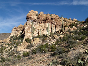
Canyon to Canyon and back by CannondaleKid  Overview OverviewThis hike provides an alternate route into the White Canyon Wilderness from the north. Although listed as a 7-mile round-trip, you can continue as far into White Canyon as you have the time and inclination. Warning If you do not have a very capable high-clearance (preferably 4x4) vehicle, it will add another 7-miles to the round-trip.
The trailhead is near the geographical center (north-south) of Wood Canyon near the end of old Forest Road 1039. Start off following the wash to the southeast for about a quarter-mile, where you will pass Wood Canyon Spring. If you happen to notice the large cave on your left, you might want to check it out. Just past the cave, the wash curves toward the south, not that you need to worry because all you need do is follow the wash. There is a reasonably easy trail to follow for the first 1.5 miles until you reach your first fork-in-the-canyon. Choose the fork to the left, and then if you stay toward the right side of the wash, you can follow a series of faint here-one-moment, gone-the-next game trails. You may be tempted to drop into the wash at times, but until you reach the White Canyon Wilderness fence-line, you will be better off staying 50-150 feet above the wash. At the 2.5-mile point, you will reach the fence marking the northern border of the White Canyon Wilderness. If you are in the center of the wash, walk 50 feet to your left, and you can probably step over the fence and continue. If you are slightly west of the wash, you can pass through a gate. (33.19187 -111.10323) About a quarter-mile into the wilderness is the first of two large pour-offs. This one can be bypassed reasonably easily by staying 100 feet or so to the right. While the slope might look steep, it's just a matter of one step at a time. Another quarter-mile, and you will reach the second and larger pour-off. This one can also be bypassed on the right after a bit of a climb. From here on, you can pretty much pick whatever route suits your fancy. Once in the flat open wash at the end, turning right at the first 'Y' will bring you into White Canyon proper. From here on, however far you wish to go is up to you. Enjoy! While you can retrace your route on the return trip, I would highly recommend an arc about 0.25 mi east of the two pour-offs, bypassing both with a higher (and more scenic) route. Water Sources Wood Canyon Spring, White Water Spring, and seasonal flow in both Wood Canyon and White Canyon. Camping Yes! Check out the scenery and pick your spot! Gate Policy: If a gate is closed upon arrival, leave it closed after you go through. If it is open, leave it open. Leaving a closed gate open may put cattle in danger. Closing an open gate may cut them off from water. Please be respectful, leave gates as found. The exception is signage on the gate directing you otherwise. Check out the Official Route and Triplogs. Leave No Trace and +Add a Triplog after your hike to support this local community. | |||||||||||||||||||||||||||||||||||||||||||||||||||||||||||||||||||||||||||||||||||||||||||||||||||||||||||||||||||||||||||||||||||||||||||||||||||||||||||||||||||||||||||||||||||||||||||||||||||||||||||||