Route Editor

| Guide | ♦ | 2 Triplogs | 0 Topics |
details | drive | no permit | forecast | route |
stats |
photos | triplogs | topics | location |
| 24 | 2 | 0 |
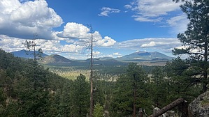
Boulders and needles between the privates by NitroTheWolf  Overview OverviewGovernment Hill Elevation: 8,450 feet Prominence: 706 feet History Government Hill is one of the many knolls and mountains that share the Government name, located in the Flagstaff / Parks area. Why this one is called Government Hill and not Government Mountain, even though the hill has a higher elevation, is unknown. Hike Best way up from the parking area is to follow the southernmost ridgeline as it goes up. There's a steep incline at the beginning as you climb 300 feet in a short distance, but that's probably the steepest section of the hike. As you continue up the ridgeline, there's evidence of a game trail that you can follow. Whether this trail was created by loggers or game is unknown, but it's an easy trail to follow. As you reach the summit, there's a fair amount of boulders along the ridgeline, but it's not too difficult to navigate. Not much as the summit and no summit log, at least not one I could find. Something interesting is what looks to be the ruins of a cabin at about 0.2 miles north of the summit in the saddle. While its purpose is unknown, my theory is that it was used as a storage area for logging efforts. Continue down the way you came, make sure you have good shoes as the going down can be slippery with the bed of pine needles on the ground.
Lots of dispersed camping spots on the western side of the hill. Lots of private lots around here, so heed all no trespassing signs and check a parcel map before setting up camp. Check out the Official Route and Triplogs. Leave No Trace and +Add a Triplog after your hike to support this local community. | |||||||||||||||||||||||||||||||||||||||||||||||||||||||||||||||||||||||||||||||||||||||||||||||