Route Editor

| Guide | ♦ | 1 Triplog | 0 Topics |
details | drive | no permit | forecast | map |
stats |
photos | triplog | topics | location |
| 18 | 1 | 0 |
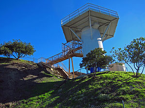
"Cold War" Military History by Grasshopper  The recommended Upper Park / TH Start is within San Vicente Mountain Park and the Lower W. Manderville Fire Road Park / TH Start is within the Manderville Canyon Park.
During the "Cold War" period this was a military reservation. LA96C was one of the NIKE missile sites that protected Los Angeles from a feared attack by Soviet bombers. It was an active battery from 1956 - 1968 with radar searching the sky for enemy airplanes. In 1962 NIKE officials claimed, "Whatever tomorrow brings...NIKE will be watching, always ready. In the 1960's new military technology made the NIKE missiles obsolete, and the site has now been made into a park. Unfortunately, Mother Nature is reclaiming the military ruins. Check out the Triplog. Leave No Trace and +Add a Triplog after your hike to support this local community. | ||||||||||||||||||||||||||||||||||||||||||||||||||||||||||||||||||||||||||||