Route Editor

| Guide | ♦ | 8 Triplogs | 0 Topics |
details | drive | no permit | forecast | map |
stats |
photos | triplogs | topics | location |
| 41 | 8 | 0 |
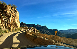
 Technically the Apache Trail begins at Mill Avenue in Tempe. The scenic portion of the road begins in Apache Junction at the intersection of Idaho Road. It continues approximately 40 miles east through the Superstition Mountains until ending at Roosevelt Dam and the junction with State Route 188. Technically the Apache Trail begins at Mill Avenue in Tempe. The scenic portion of the road begins in Apache Junction at the intersection of Idaho Road. It continues approximately 40 miles east through the Superstition Mountains until ending at Roosevelt Dam and the junction with State Route 188.The western half of the road is paved, but the pavement ends a few miles east of Canyon Lake. The dirt road is graded, but washboards and ruts are common. The road is narrow and features numerous sharp curves and steep hills, often with no safety barriers. Some creek crossings are subject to flooding during rain. The road is generally not recommended for RVs or vehicles towing trailers. Check out the Triplogs. Leave No Trace and +Add a Triplog after your scenic drive to support this local community. | ||||||||||||||||||||||||||||||||||||||||||||||||||||||||||