username
X
password
register
for free!
help
  
  🔥

Coon Creek Ruins Overlook via FR3368, AZ

Guide 6 Triplogs  0 Topics
  3.5 of 5  
Fav
Wish
1
details
drive
no permit
forecast
🔥
route  
stats
photos
triplogs
topics
location
86 6 0
HAZ reminds you to respect the ruins. Please read the Archaeological Resources Protection Act of 1979 & Ruins Etiquette
Statistics
tap row or icons for details
Difficulty 0.5 of 5
Route Finding 1 of 5
Distance Round Trip 0.04 miles
Trailhead Elevation 4,383 feet
Elevation Gain -10 feet
Accumulated Gain 10 feet
Kokopelli Seeds 0.09
 Interest Off-Trail Hiking & Ruins
feature photo
Photos Viewed All MineFollowing
Inaugural Calculation on Button Tap!
15  2015-01-25
Upper Deep Creek
trekkin_gecko
29  2015-01-25
Upper Deep Creek
Oregon_Hiker
4  2015-01-25 Grasshopper
30  2015-01-25 AZLumberjack
8  2015-01-25 varmit
Author
author avatar Guides 48
Routes 510
Photos 9,555
Trips 578 map ( 5,972 miles )
Age 79 Male Gender
Location Scottsdale, AZ
Historical Weather
Trailhead Forecast
Radar Map
Expand Map
Preferred Mar, Nov, Apr, Feb
Sun  5:59am - 6:45pm
Official Route
 
1 Alternative
 
Historic Fire Perimeteracres
🔥 1976 Bull Fire4.4k


remove free decal offer
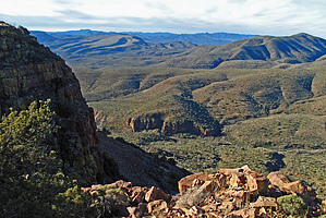
leg stretcher
by Grasshopper

  
While in the FR203A Sierra Ancha area of the Bull Canyon TH to hike other trail and off-trail options, this spur road drive and very short ~30 yards walk one way from the FR3368 road end "Cliff Overlook" to view the scenic and ancient Coon Creek Cliff Dwelling Ruins Site is a worthy addition to your planned day.


Note
Best viewed in the mid-morning hours due to sun location across Coon Creek Canyon.

2015-01-28 Grasshopper


    Check out the Official Route and Triplogs.
    Leave No Trace and +Add a Triplog after your walk/tour to support this local community.
    WARNING! Hiking and outdoor related sports can be dangerous. Be responsible and prepare for the trip. Study the area you are entering and plan accordingly. Dress for the current and unexpected weather changes. Take plenty of water. Never go alone. Make an itinerary with your plan(s), route(s), destination(s) and expected return time. Give your itinerary to trusted family and/or friends.

     Permit $$
    None


     Directions
    or
     Road
    High Clearance possible when dry

    To walk/tour
    From the Phoenix area:
    On Hwy 60 in Globe(MP247.0), take State Hwy 188 northwest toward Lake Roosevelt for 14.7mls to its junction with State Hwy 288 (MP229.4); turn Right on State Hwy 288 and drive north for 6.9 miles to signed Cherry Creek Rd (FR203); Turn right(east) on maintained, gravel road FR203 and drive for 10.2 miles just past cattle guard to the junction with signed FR203A; Turn left(north) on high clearance (light truck tires recommended) FR203A and follow this very scenic, some one-way narrow sections with exposure, ridgeline climbing, seldom maintained FR203A for 2.75 miles to the signed intersection with FR3368; Turn west (left) onto FR3368 for 0.3 miles to the road end at Park/TH Start (see recommended and posted GPS Driving Route and ~30 yards one way Walking Route);
    page created by Grasshopper on Jan 27 2015 6:09 pm
     90+° 8am - 6pm kills
    helpcorrectionissue

    end of page marker