username
X
password
register
for free!
help
 This is likely a great time to hike this trail!  Check out "Preferred" months below, keep in mind this is an estimate.
 

Thomas Creek / Dry Pond / Whites Creek Loop, NV

Guide 0 Triplogs  0 Topics
  0 of 5  
Fav
Wish
0
NV > Reno
details
drive
no permit
forecast
route  
stats
photos
triplogs
topics
location
27 0 0
Statistics
tap row or icons for details
Difficulty 3 of 5
Route Finding 2 of 5
Distance Loop 6.7 miles
Trailhead Elevation 6,025 feet
Elevation Gain 1,000 feet
Accumulated Gain 1,125 feet
Avg Time Round Trip 3.5 hours
Kokopelli Seeds 12.33
 Interest Seasonal Creek & Perennial Creek
 Backpack Yes
feature photo
Photos Viewed All MineFollowing
Will recalculate on button tap!
27  2015-01-30 AZClaimjumper
Author
author avatar Guides 11
Routes 31
Photos 1,578
Trips 25 map ( 193 miles )
Age 80 Male Gender
Location Reno, Nevada
Associated Areas
list map done
Reno Region
Historical Weather
Trailhead Forecast
Radar Map
Expand Map
Preferred May, Oct, Sep, Jun → 9 AM
Seasons   Early Spring to Late Autumn
Sun  5:31am - 6:25pm
Official Route
 
0 Alternative


babbling brook
by AZClaimjumper

 Likely In-Season!
This loop hike began & ended @Thomas Creek Trailhead (N39° 23.604' W119° 50.297') moving in a counter clockwise direction. There is plenty of parking; the facilities are strictly outhouse. Keep your eyes open throughout this loop hike because it is a very popular loop for those on mountain bikes.


Motorized vehicles prohibited.
remove free decal offer
Take your camera.

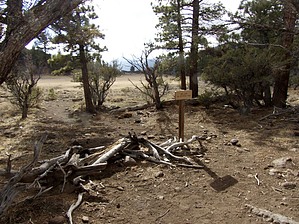
Thomas Creek Trail
Parallels the creek & you'll be hiking westerly under a nice tree canopy & enjoying the sound of a babbling brook. After approximately 1.5 miles you'll arrive at a signpost, Turn LEFT (south) & head up Dry Pond Trail.

Dry Pond Trail
Starting at the signpost is where you're going to be gaining your elevation. Dry Pond is at the plateau (top); there are numerous shaded places to rest, take a nutrition break & enjoy the scene. AFTER you pass Dry Pond, you'll start heading down, the trail which will eventually take you across a bridge where you'll intersect with White's Creek Trail.

White's Creek Trail
After you cross the bridge, turn EAST onto White's Creek Trail. The trail will parallel the creek which will be to your left. You'll continue down until you intersect with a signpost Dry Pond trail/Timberline Road; take the Timberline Road Trail to your LEFT.

Timberline Road
When you reach the junction go NORTH (left); the paved road will take you back to Thomas Creek Trailhead / Parking.

I'd suggest taking a backpack for your water, nutrition, & clothing/rain gear depending on the weather.

2015-02-01 AZClaimjumper


    Check out the Official Route.
    Leave No Trace and +Add a Triplog after your hike to support this local community.
    WARNING! Hiking and outdoor related sports can be dangerous. Be responsible and prepare for the trip. Study the area you are entering and plan accordingly. Dress for the current and unexpected weather changes. Take plenty of water. Never go alone. Make an itinerary with your plan(s), route(s), destination(s) and expected return time. Give your itinerary to trusted family and/or friends.

     Permit $$
    None


     Directions
    or
     Road
    Connector trail - Not Applicable

    To hike
    From Highway 580 (US 395), turn WEST onto Mt Rose Highway (state Rt 431), After 5 miles take a right on Timberline Drive. About ½ mile thru a residential area, just follow the signs point to Thomas Creek Trailhead
    page created by AZClaimjumper on Jan 31 2015 5:32 pm
     90+° 8am - 6pm kills
    helpcorrectionissue

    end of page marker