username
X
password
register
for free!
help
 

Red Canyon - Clifton, AZ

Guide 5 Triplogs  0 Topics
  3 of 5  
Fav
Wish
1
details
drive
no permit
forecast
map
stats
photos
triplogs
topics
location
36 5 0
Statistics
tap row or icons for details
Difficulty 2 of 5
Distance Round Trip 4.5 miles
Trailhead Elevation 3,611 feet
Elevation Gain 800 feet
Accumulated Gain 850 feet
Kokopelli Seeds 8.75
 Interest Off-Trail Hiking, Seasonal Waterfall & Seasonal Creek
unreported if dogs are allowed
editedit > ops > dogs to adjust
feature photo
Photos Viewed All MineFollowing
15  2011-02-18 SkyIslander18
8  2011-01-13 PrestonSands
6  2009-12-10 PrestonSands
7  2009-01-08 PrestonSands
Author
author avatar Guides 16,843
Routes 17,472
Photos 24
Trips 1 map ( 6 miles )
Age 28 Male Gender
Location HAZ, TrailDEX
Associated Areas
list map done
Tucson Region
Historical Weather
Trailhead Forecast
Expand Map
Preferred Nov, Mar, Feb, Jan
Sun  5:53am - 6:38pm
0 Route
 
0 Alternative


remove free decal offer

Guide Needed
Publish Full Detail Guide


Use +Add above to share photos and triplogs
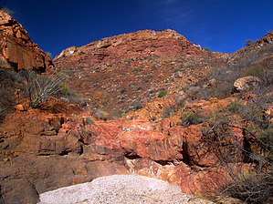
Overview: This is a red rock canyon running south from Mulligan Peak, just east of Clifton, AZ. An old mine tunnel, and a few short seasonal waterfalls await explorers, but beware of this canyon's giant cougar!


    Check out the Triplogs.
    Leave No Trace and +Add a Triplog after your hike to support this local community.
    WARNING! Hiking and outdoor related sports can be dangerous. Be responsible and prepare for the trip. Study the area you are entering and plan accordingly. Dress for the current and unexpected weather changes. Take plenty of water. Never go alone. Make an itinerary with your plan(s), route(s), destination(s) and expected return time. Give your itinerary to trusted family and/or friends.

     Permit $$
    None


     Directions
    or
     Road
    Paved - Car Okay

    To hike
    From Safford, head east on Highway 70/191. 10 miles from Safford, the highway splits, turn left onto Highway 191 and follow it for another 23.75 miles to a (4-way) highway junction known as "3-Way" (old drive-in movie theater and store). Turn left to remain on Highway 191. From the 3-Way junction, head north on highway 191 for approximately 8.3 miles to milepost 162.8, in the town of Clifton (next to the Copper Era newspaper building). At this point, turn left onto Ward Canyon Road, and follow it for about 1.2 miles to the obvious mouth of Red Canyon on the left. Park along Ward Canyon Road and start hiking.
    page created by PrestonSands on Feb 09 2009 9:17 pm
     90+° 8am - 6pm kills
    helpcorrectionissue

    end of page marker