 Route Editor

| Guide | ♦ | 22 Triplogs | 0 Topics |
details | drive | permit | forecast | route |
stats |
photos | triplogs | topics | location |
| 113 | 22 | 0 |
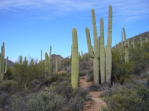
Saguaro Heaven by HAZ_Hikebot  The Bowen Trail is a new addition to the Tucson Mountain Park and is only 0.8 miles long. A nice hike is to the Old Stone House. The house was built in the 1930s by Sherry Bowen, a typesetter and, later city editor for the Arizona Daily Star. Bowen brought his wife, Ruby, to Tucson from Rockford, Illinois, in the late twenties, hoping that the climate would help her serious heart condition. They homesteaded in the Tucson Mountains eventually owning two thousand acres. Ruby kept a diary of her first year in the Tucson Mountains. She wrote of the wild mountain sheep that came to the base of the cliffs nearly every evening to graze. A mountain lion would pace about when she was cooking meat and one time attempted to get in the window. The valley and their homestead became part of the Tucson Mountain Park in 1983. The Bowen Trail is a new addition to the Tucson Mountain Park and is only 0.8 miles long. A nice hike is to the Old Stone House. The house was built in the 1930s by Sherry Bowen, a typesetter and, later city editor for the Arizona Daily Star. Bowen brought his wife, Ruby, to Tucson from Rockford, Illinois, in the late twenties, hoping that the climate would help her serious heart condition. They homesteaded in the Tucson Mountains eventually owning two thousand acres. Ruby kept a diary of her first year in the Tucson Mountains. She wrote of the wild mountain sheep that came to the base of the cliffs nearly every evening to graze. A mountain lion would pace about when she was cooking meat and one time attempted to get in the window. The valley and their homestead became part of the Tucson Mountain Park in 1983.A nice loop hike of 4.6 miles can be made by following the Bowen Trail to the Old Stone House and then following the Yetman Trail another 1.0 miles south to a trail junction. You can then take the old 4WD road past the water tank back to the hotel parking lot or pick up the Rock Wren Trail as it loops around the south side of the water tank to the Star Pass Trailhead at the south end of Clearwater Drive. It's only a 1/2 mile hike on the road back to the hotel parking lot.
Check out the Official Route and Triplogs. Leave No Trace and +Add a Triplog after your hike to support this local community. One-Way Notice This hike is listed as One-Way. When hiking several trails on a single "hike", log it with a generic name that describes the hike. Then link the trails traveled, check out the example. | |||||||||||||||||||||||||||||||||||||||||||||||||||||||||||||||||||||||||||||||||||||||||||||||||||||||||||||||||||||||||||||||||||||||||||||||||||||||||||||||||||||||||||||||||||


