 Route Editor

| Guide | ♦ | 7 Triplogs | 1 Topic |
details | drive | no permit | forecast | map |
stats |
photos | triplogs | topic | location |
| 59 | 7 | 1 |
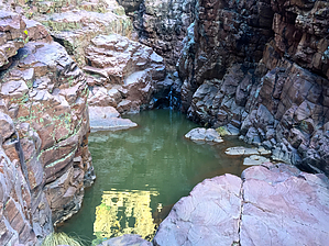
  Note NoteThe difficulty may be incorrectly rated. Edit if you know better. Overview A narrow canyon that accesses a popular climbing area known as Isolation Canyon. The hike features flowing water during wet seasons. Dry seasons will still provide seasonal pools of water, but not regular flow. Several falls require down climbs with existing ropes or steep bypasses. Distances are up to you (one-way): Junction with canyon draining from the east with several significant falls: ~0.75mi Main climbing area: ~1.25mi Steep drainage exit to the northwest ~2.0mi Oak Spring Canyon: ~2.5mi Private Property boundary: ~3.0mi
After 3 miles in the canyon at private property head west via old road toward Oak Spring jct with AZT and Oak Spring Trail. It's about four more miles back to the parking area. Use trails above the Isolation climbing area to provide shorter loop options. Check out the Triplogs. Leave No Trace and +Add a Triplog after your hike to support this local community. One-Way Notice This hike is listed as One-Way. When hiking several trails on a single "hike", log it with a generic name that describes the hike. Then link the trails traveled, check out the example. | ||||||||||||||||||||||||||||||||||||||||||||||||||||||||||||||||||||||||||


