 Route Editor

| Guide | ♦ | 52 Triplogs | 0 Topics |
details | drive | no permit | forecast | route |
stats |
photos | triplogs | topics | location |
| 436 | 52 | 0 |
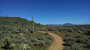
No Badgers Here by Unregistered   Badger Brawl Trail is another new trail, around 2014, in the Sonoran Preserve-North. The trail itself is 3.4 miles one way. But to get there, you will have to hike a half-mile up the Apache Wash Loop to the start of this trail. When you reach the end of the trail, you will be at 40th street. Now you may be able to park there, but I am not sure. Badger Brawl Trail is another new trail, around 2014, in the Sonoran Preserve-North. The trail itself is 3.4 miles one way. But to get there, you will have to hike a half-mile up the Apache Wash Loop to the start of this trail. When you reach the end of the trail, you will be at 40th street. Now you may be able to park there, but I am not sure.The trail itself is relatively flat. You will cross several dry river beds, and some are rather broad. I would not recommend hiking this trail after a big rainstorm. It looked like it has flooded in the past. It is an excellent trail for bike riders.
Picturesque Saguaros and flowers make this a lovely spring hike. The trail itself is very well-marked and easy to follow. Enjoy!
Check out the Official Route and Triplogs. Leave No Trace and +Add a Triplog after your hike to support this local community. One-Way Notice This hike is listed as One-Way. When hiking several trails on a single "hike", log it with a generic name that describes the hike. Then link the trails traveled, check out the example. | |||||||||||||||||||||||||||||||||||||||||||||||||||||||||||||||||||||||||||||||||||||||||||||||||||||||||||||||||||||||||||||||||||||||||||||||||||||||||||||||||||||||||||||||||||||||||


