username
X
password
register
for free!
help
 

Oatman Massacre / Fourr Cemetery, AZ

Guide 10 Triplogs  0 Topics
  2.8 of 5  
Fav
Wish
2
details
drive
no permit
forecast
route  
stats
photos
triplogs
topics
location
262 10 0
Statistics
tap row or icons for details
Difficulty 1 of 5
Route Finding 1 of 5
Distance Round Trip 2 miles
Trailhead Elevation 521 feet
Elevation Gain 20 feet
Accumulated Gain 20 feet
Avg Time Round Trip 1.5 hours
Kokopelli Seeds 2.1
 Interest Off-Trail Hiking & Historic
unreported if dogs are allowed
editedit > ops > dogs to adjust
feature photo
Photos Viewed All MineFollowing
Will recalculate on button tap!
17  2021-02-13
Oatman Grave Loop
Hansenaz
27  2019-11-16
Gila Oatman Loop
Hansenaz
11  2017-08-02 Stoic
83  2017-01-15 AZHiker456
15  2017-01-02 AZWanderingBear
15  2016-08-14 trekkintoo
8  2015-03-30 kingsnake
53  2015-03-30
Oatman-Sundad-Aqua Caliente
Stoic
Page 1,  2
Author
author avatar Guides 116
Routes 337
Photos 11,399
Trips 894 map ( 8,139 miles )
Age 63 Male Gender
Location Sunnyslope, PHX
Associated Areas
list map done
Southwest Region
Historical Weather
Trailhead Forecast
Radar Map
Expand Map
Preferred Dec, Jan, Feb, Nov
Sun  6:10am - 6:52pm
Official Route & 2 Rts
 
1 Alternative


Rough, short, lives
by kingsnake

Visiting the Fourr Cemetery and Oatman Massacre site is an interesting side trip from the Painted Rock Petroglyph Site.


Fourr Cemetery
Twenty-something years after the Oatman Massacre, William and Lucinda Fourr, and their family settled in the area., where William ranched and served as an agent at the Butterfield Stage stop. Of the six children they had between their marriage in 1868, and when they left in the area in 1880, four died here. The Fouur Cemetery is where the children are buried: Seven-year-old A.F., month old F.F. -- on the same sad date in January 1877 -- and an unnamed baby, stillborn. (I'm not sure about the fourth child.) The Fourrs eventually had eight children who survived to adulthood, with William living until 1934, and Lucinda in 1942. Stanley Heisey, a Life Scout of Troop 263, has installed a bench, a logbook, and otherwise restored the site.
remove free decal offer
After paying your respects to the Fourr children, it is a slippery, dusty, one-mile drive to the Oatman Memorial. As the area is a Gila River flood plain, and at least a semi-functional farm, there may be brush that has been washed/plowed into the road. You may need to stop short and walk a bit.

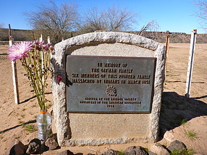
Oatman Massacre
The Oatman family were Mormon pioneers in a party that left Independence, MO, in August 1850. The original party of 85-93 schismatic Brewsterites, further splintered as it traveled west until the Oatman family was going it alone when they reached this area. Despite being warned about hostile Indians, they proceeded. It was not a wise choice. The parents, Royce and Mary, and four of the seven children were killed. A son, Lorenzo, 15, escaped despite being wounded. 14-year old Olive and 7-year old Mary Ann were captured. Mary Ann died during a later famine at age 10 or 11, while Olive assimilated, possibly having children, before being repatriated at age 19.

The Daughters of the American Revolution erected a memorial to the Oatman family in 1954. It, however, is not the massacre site, which is where the Oatman's who perished are buried. The actual massacre site is a quarter-mile WSW, on top of the Gila River's south bluff, a short additional walk.

2015-02-25 kingsnake


    Check out the Official Route and Triplogs.
    Leave No Trace and +Add a Triplog after your hike to support this local community.
    WARNING! Hiking and outdoor related sports can be dangerous. Be responsible and prepare for the trip. Study the area you are entering and plan accordingly. Dress for the current and unexpected weather changes. Take plenty of water. Never go alone. Make an itinerary with your plan(s), route(s), destination(s) and expected return time. Give your itinerary to trusted family and/or friends.

     Permit $$
    None


     Directions
    or
     Road
    FR / Dirt Road / Gravel - Car Okay

    To hike
    From the Gila Bend ... drive ~12.0 miles west on I-8 to exit 102. Go north, then west, on Painted Rock Rd. for 11 miles to the Painted Rock Petroglyph Site. Divert right onto Rocky Point Rd, instead of entering the park. Rocky Point Rd. is a decent gravel surface, but cars may wish to take it a bit slower to avoid kicking anything up into the oil pan. Immediately after crossing the Gila River, turn left, following a fence / farmland on your right, as you curve around the private property. When you reach the southwest corner of the farmland, turn left onto Oatman Rd. Follow the southern bluff of the Gila River (on your left) for ~1.0 miles. Park at the Fouur Cemetery, which is at the base of the bluff, just past the water station. Car drivable to that point. The road to the Oatman Memorial is very deep, fine dust, requiring at least AWD.
    page created by kingsnake on Feb 25 2015 12:06 pm
     90+° 8am - 6pm kills
    helpcorrectionissue

    end of page marker