Route Editor

| Guide | ♦ | 19 Triplogs | 0 Topics |
details | drive | no permit | forecast | route |
stats |
photos | triplogs | topics | location |
| 282 | 19 | 0 |
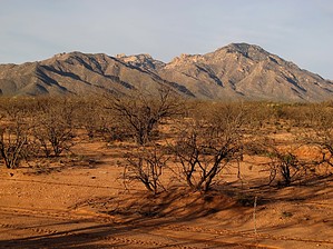
severely overgrown by vagabondjeff   Overview OverviewThis is a hike to the highpoint of the Coyote Mountains. While the peak is technically not named, I've labeled it Coyote Peak in that it might make it easier for people to search for. It is an extremely rigorous and challenging hike. While the distance and elevation gain are not necessarily difficult, the route finding and overgrowth on the "trail" are. Warning Be prepared for cactus, cat's claw, shin daggers, spanish bayonet, scrub oak, and more; particularly after attaining the ridge line. I highly recommend long pants, sleeves, and even gaiters.
Supposedly, the trail that you will eventually hike on was built by a local rancher some decades ago. He had it built for his wife to ride her horse to the summit of the Coyote Mountains. It does to the top but is severely overgrown in places and seems to disappear in others. It's often only visible by a few rocks that seem to be in too straight of a line. As it moves along near the top of the ridgeline in many steep places, it makes tight little switchbacks. It is amazing the amount of work that was put into building it. Hike The hike's initial part getting to the ridgeline is pretty straightforward, although you will lose and re-find the trail many times as it weaves it's way up the mountainside. After attaining the ridgeline, it moves back and forth across the ridgeline and around many of the sub-peaks along the way. Before you start the last steep climb to the summit ridge, it moves well off the ridge to the southeast before a sharp right turn where you should stay in the gully along a wall of rocks. On our ascent, we moved too far to the west and encountered steep, treacherous terrain. Once near the summit ridge, you will experience lots of scrub oak growing across the trail. Water Sources I don't believe there is any reliable water source. Check out the Official Route and Triplogs. Note This is a more difficult hike. It would be unwise to attempt this without prior experience hiking. Leave No Trace and +Add a Triplog after your hike to support this local community. | ||||||||||||||||||||||||||||||||||||||||||||||||||||||||||||||||||||||||||||||||||||||||