Route Editor

| Guide | ♦ | 3 Triplogs | 0 Topics |
details | drive | no permit | forecast | route |
stats |
photos | triplogs | topics | location |
| 66 | 3 | 0 |
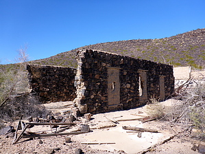
Enjoy the soothing waters by kingsnake  History HistoryAgua Caliente was named for the hot water spring which was used as a spa from pre-European times until the water was drained dry by farmers & ranchers in the late 1940s. I read somewhere that the Indians who massacred the Oatman family stopped here for a relaxing bath with their two young captives, Mary Ann and Olive Oatman. On March 30, 1862, nearby Stanwix Ranch / Stanwix Station, a stop on the Butterfield Overland Stage, was the site of the westernmost battle of the Civil War. The California Column, of that war, also stopped at the Agua Caliente hot springs to partake of the soothing waters. The reputation spread, and in 1897 a 22-room spa was built. The spa was used during World War II by the officers (of course) of nearby Camp Horn. Walk/Tour The spa building is still standing, and intact, but it is signed off with "no trespassing" warnings. There is also a large satellite antenna outside. It looks like the grounds are occupied, so best take any pictures from the road. Just southwest of the spa, on the west side of the road, is an intact old stone building, which is fenced off and has metallic screens over the windows. The rest of the Agua Caliente, on the east side of the road, opposite the farm, is free to explore.
On the west side of the road, the Pioneer Cemetery has burials from 1880 to at least 2007. More recent burials are at the south end, older at the north, nearer the ruins. I found at least one obviously empty grave. (Spooky.) Many of the older graves are marked with only a wooden cross, or have no remaining memorial and are now only mounds. Check out the Official Route and Triplogs. Leave No Trace and +Add a Triplog after your walk/tour to support this local community. | |||||||||||||||||||||||||||||||||||||||||||||||||||||||||||||||||||||||||||