 Route Editor

| Guide | ♦ | 5 Triplogs | 0 Topics |
details | drive | no permit | forecast | route |
stats |
photos | triplogs | topics | location |
| 109 | 5 | 0 |
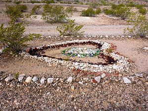
The Hills Have Eyes by kingsnake  There's not much information on Sundad available on the internet, but it was established as a tuberculosis sanitarium in the 1920s. With TB being highly contagious, the distance from Phoenix kept healthy folks safe, while it was felt the dry, warm air would be beneficial to the patients. The sanitarium did not last long. In more recent decades, it has been a party spot for off-roaders. That is not as bad as it sounds and is actually quite cool, as they have turned the rocks and many bottles into interesting rock art designs. (Look at sat view!) "Sundad" is spelled out several times, and there are circles, diamonds, wheels, flowers, sunrises, arrows, and many other designs. Pretty cool! There's not much information on Sundad available on the internet, but it was established as a tuberculosis sanitarium in the 1920s. With TB being highly contagious, the distance from Phoenix kept healthy folks safe, while it was felt the dry, warm air would be beneficial to the patients. The sanitarium did not last long. In more recent decades, it has been a party spot for off-roaders. That is not as bad as it sounds and is actually quite cool, as they have turned the rocks and many bottles into interesting rock art designs. (Look at sat view!) "Sundad" is spelled out several times, and there are circles, diamonds, wheels, flowers, sunrises, arrows, and many other designs. Pretty cool!Watch your step: Lots of nails as well.
The entire Sundad site is about 500 yards south-to-north and maybe 100 yards wide. Check out the Official Route and Triplogs. Leave No Trace and +Add a Triplog after your hike to support this local community. One-Way Notice This hike is listed as One-Way. When hiking several trails on a single "hike", log it with a generic name that describes the hike. Then link the trails traveled, check out the example. | |||||||||||||||||||||||||||||||||||||||||||||||||||||||||||||||||||||||||||||||||||||||||||||||||||||||||||||||||||||||||||||||||||||||||||||||||||||||||||


