Route Editor

| Guide | ♦ | 2 Triplogs | 0 Topics |
details | drive | no permit | forecast | 🔥 route |
stats |
photos | triplogs | topics | location |
| 48 | 2 | 0 |
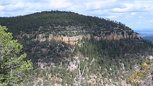
Follow the old road... I don't see any road! by CannondaleKid   Overview OverviewBaker Mountain is located in the Aztec Peak Quadrangle in Gila County. With a rise of 208' and an elevation of 7588', its Arizona Peaks Rank is 4555. GPS coordinates: 33.84238 -110.93927 Baker Mountain is the long ridge between Workman Creek and Reynolds Creek for those familiar with the area. Warning The obvious ones... watch the weather and watch for bears. We saw plenty of scat and also met a hunter who encounters them frequently, but don't worry he said, they just run away.
I've found nothing specific about all the old logging roads, but of course, there is an ancient ruin site on the cliffs above Workman Creek Falls. Hike Since probably 90% of the slopes of Baker Mountain are cliffs, unless you are really into scaling cliffs, there is but one completely non-technical route, albeit a long and winding one. The trailhead is on Forest Road 487, where an old logging road begins, about 0.3 miles past Workman Creek Falls (upstream). Arizona Topo refers to it as 'Trail 151', which is likely an old northern continuation of Abbey's Way trail which passes through the Peterson Ranch meadow and up to Aztec Peak. Parking is available in the open area along FR 487 next to the loose dirt slope. From there, begin by taking a northeasterly heading, following along the and up the slope to the left of the small creek. Continue until you connect with the old logging road, which is a far cry from even looking like it was once a road. Think of an old road that hasn't been used in 50-75 years, and you'll get the idea. Whatever, if you aren't following the GPS route provided, you will be well-pressed at times to keep from losing it. It is easy to follow for the next quarter-mile once you reach the 90° turn to the left (from NE to NW). After passing through a fence (the gate has been long gone), it's time for another 90° left turn, but exactly where to turn is the issue. We would find there used to be several logging roads going willy-nilly along the long oddly-shaped ridge, so it's quite easy to lose track of the 'correct' route, but don't worry, since there are very few sections of thick brush, as long as you are continuing in the right direction, any route you take is fine. Besides, what's left of a road will die off about a half-mile from the summit. From there, you may pick and choose your own route, as long as you continue in a northerly direction. The last bit of climbing toward the summit is an easy grade, the hardest part avoiding or climbing over deadfall. Unfortunately, since the summit is wide, flat, and surrounded by pine trees, the view is not exactly awe-inspiring. But in my opinion, the peacefulness of the wind whispering through the pines is well worth the effort. Route The official GPS route is edited to use what's left of the roads as much as possible. The 'Scenic Spur' GPS route provides an optional side-trip. Either follow the faint logging road out, returning the same way, along our wandering route or just follow your whim. And remember, whatever route you take is correct, as long as you find your way back, that is. Water Sources While there may be the odd small pools here and there, they are not to be relied upon. The small creek adjacent to the trailhead appears to have constant flow (complete with gauging station), and of course, Workman Creek is very close. Camping A few dispersed camping sites within a quarter-mile just off Forest Road 487, along with many more sites a mile or two farther up the road to Aztec Peak. No camping at the Day Use sites along Workman Creek or the Abbey's Way Trail 151 trailhead. Gate Policy: If a gate is closed upon arrival, leave it closed after you go through. If it is open, leave it open. Leaving a closed gate open may put cattle in danger. Closing an open gate may cut them off from water. Please be respectful, leave gates as found. The exception is signage on the gate directing you otherwise. Check out the Official Route and Triplogs. Leave No Trace and +Add a Triplog after your hike to support this local community. | |||||||||||||||||||||||||||||||||||||||||||||||||||||||||||||||||||||||||||||||||||||||||||||||||||||||||||||||