Route Editor

| Guide | ♦ | 3 Triplogs | 0 Topics |
details | drive | no permit | forecast | route |
stats |
photos | triplogs | topics | location |
| 134 | 3 | 0 |
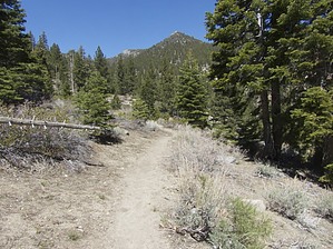
I've included a geocoded photoset.
You're going to have fun at FOUR creek crossings, where the rocks & logs are wet, slippery, & unstable. Portions of this hike parallel Jones Creek & part of this hike parallel's White's Creek, both of which add sounds of babbling brooks. This true loop hike has it all, portions of the trail are covered with a nice tree canopy; portions of the trail are open, some places you'll be walking on soft dirt, other places you'll be walking on rocks. There are multiple big trees lying across the trail that you'll have to climb up & over. There are 6 switchbacks on the way to the highest point (8,135') at the trail junction of Church's Pond/Jones-Whites Creek loop where you'll enjoy views of Slide Mtn, Mt Rose, & Washoe Lake. This is a favorite turn around point for many hikers after a nutrition break. I preferred to continue on the trail past the high point 100-200 yards, where there is plenty of tree cover & shade for my nutrition break. I started out with 2 liters of water in a bladder inside my backpack, however, I made the loop hike in temperatures of 50º's - 65º & very gently breezes all day. I drank 1 of the 2 liters. IF you make this hike in hotter weather I'd like to suggest you start out with 3 liters of water. The first 4 miles of this hike are steep & you'll be sucking wind. The last 6+ miles are mostly downhill. BE PREPARED for weather changes & let others know what trail you'll be hiking. Your GPS will keep you on the trail if you download the track into your GPS. There is a waypoint I've identified as DON'T MISS, a turn to the right onto another trail going back to the Galena Creek Visitor Center. If you've downloaded the track into your GPS you'll be OK. After you complete the loop if you drive down to the Galena Creek Visitor Center you'll find indoor restrooms with hot & cold water + coffee is available for a $1.00 donation. Please observe trail etiquette by passing on the right; the hiker moving UPHILL, has the right-of-way. Check out the Official Route and Triplogs. Leave No Trace and +Add a Triplog after your hike to support this local community. | |||||||||||||||||||||||||||||||||||||||||||||||||||||||||||||||||||||||||||||||||||||||||||||||||||||||||||||||||||||||||||||||||||||||||||||||||||||||||||||||||||||||||||||