If you're going through Hell, keep on going. by Al_HikesAZ
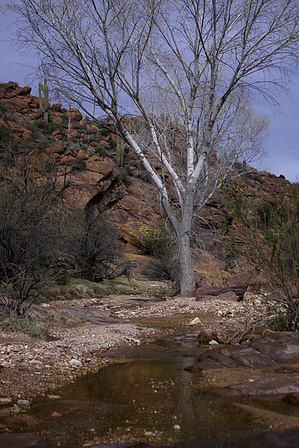
Garfias Wash flows from west to east through the middle of Hell's Canyon Wilderness into the northwest part of Lake Pleasant. This designated Wilderness is about 10,000 acres set in the rugged and scenic Hieroglyphic Mountains and managed by the BLM. The jewel of this hike is the section through the narrow Hell's Canyon. It's a beautiful riparian area with numerous interesting sections of rocks. This area is mostly volcanic rock from the Cretaceous and Tertiary periods with some granite and schist from the underlying Precambrian core. The BLM recently acquired a section of land from a private owner that basically completes this Wilderness. There is still a small section of private land that included part of Hell's Canyon. No signs were posted, but always be respectful of private property if posted.
Much of the Wilderness is surrounded by private property, so access is limited to a few spots. This hike is probably best down as a shuttle hike. Otherwise, you could simply hike the Hell's Canyon.
Park one shuttle just southwest of the bridge at the east end of Garfias Wash at Lake Pleasant. Just before the bridge is a road to the right leading to a Marina. You may need to head down to a kiosk at the Marina and pay a fee to Maricopa County to safely park a car at this trailhead. We weren't certain, so we bought the day pass to be safe. Continue up Castle Hot Springs Road. About 13 miles north of Arizona Highway 74, you will reach the historic Castle Hot Spring Resort, closed to the public. Continue up Crater Canyon, which is also private property. Bitter Creek crosses Castle Hot Springs Road about 7 miles beyond the Resort. Just past this point, head south on Cedar Basin Road. You will need 4WD for this stretch. About 2 miles south on Cedar Basin Road, you will reach Garfias Wash and the parking area.
Just start following the wash. At about 2.5 miles, you enter Hell's Canyon. It is narrow with steep walls and has lots of boulders. You can try to stay dry by scrambling around the walls, but footing can be loose on some of the walls, so be careful. The easiest way is to stick to the wash and figure that you will get your feet wet at some points. After about 2 miles, the canyon opens up, and you are back in a wider wash. Continue down the winding wash for about 4 miles. The wash widens as it approaches Lake Pleasant. Depending on the lake's water level, you may need to head to the south or head to the northeast to the road and then walk south down the road back to your cars.
WARNING! Hiking and outdoor related sports can be dangerous. Be responsible and prepare for the trip. Study the area you are entering and plan accordingly. Dress for the current and unexpected weather changes. Take plenty of water. Never go alone. Make an itinerary with your plan(s), route(s), destination(s) and expected return time. Give your itinerary to trusted family and/or friends.
Drive north from Phoenix on I-17 to Carefree Highway (exit 233). Go west on AZ Highway 74. Drive to the turnoff for Lake Pleasant at Castle Hot Springs Road(about 5.5 miles. Turn right and drive approximately 4 miles along Castle Hot Springs Road. Turn right to the Marina if a Maricopa County Regional Park Fee is required. Continue to the bridge over Garfias Wash as it enters Lake Pleasant. Park to the west just before the bridge to start the finishing end of the shuttle.
 Route Editor

 Garfias Wash flows from west to east through the middle of Hell's Canyon Wilderness into the northwest part of Lake Pleasant. This designated Wilderness is about 10,000 acres set in the rugged and scenic Hieroglyphic Mountains and managed by the BLM. The jewel of this hike is the section through the narrow Hell's Canyon. It's a beautiful riparian area with numerous interesting sections of rocks. This area is mostly volcanic rock from the Cretaceous and Tertiary periods with some granite and schist from the underlying Precambrian core. The BLM recently acquired a section of land from a private owner that basically completes this Wilderness. There is still a small section of private land that included part of Hell's Canyon. No signs were posted, but always be respectful of private property if posted.