 Route Editor

| Guide | ♦ | 1 Triplog | 0 Topics |
details | drive | permit | forecast | route |
stats |
photos | triplog | topics | location |
| 17 | 1 | 0 |
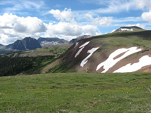
Take the High Road to the Castle by Woodsnative The route described here is a beautiful alternate route to Red Castle Lake. If you favor a shorter route with less foot and horse traffic, and don't mind a fair amount of elevation gain in exchange for great high-elevation scenery, then this is the route for you.
THE BIG HILL: You are now on the Bear River-Smith Fork Trail #091. The signage points simply to Smiths Fork. A series of long switch backs will bring you up to the top of the ridge and shortly after that, to the beginning of the Bald Mountain Trail #111. BALD MOUNTAIN: Once on top of the ridge, you will find the beginning of Bald Mountain Trail. Follow the sign marked Bald Mt. Trail southward and upward. No mention is made of Red Castle. This section of trail is still heavily forested, though most of the trees are dead. After about a mile the trail climbs above tree line and keeps on climbing. It does not go directly to the summit of Bald Mountain but skirts around the domed peak, staying just above the edge of a cliff. At the base of the cliff is beautiful Bald Lake. The next 1.5 miles of trail cross over a very large grassy meadow atop the ridge. The views of the ridges and peaks on both sides are spectacular and Red Castle itself comes into view. The highest point in the trail here is about 11,500 feet. EAST FORK SMITHS FORK: Upon descending the ridge you enter the pine forests in the next valley. After several miles the Bald Mountain trail ends in a junction with the East Fork Smiths Fork Trail. Nearby is a bridge and the beginning of the East Red Castle Trail. From here to Red Castle Lake the trail is often marked by the footprints of horses and mule trains. There are also sections where streams and marshes flood the trail with water. Continue southward to Lower Red Castle Lake and begin to look for a camping site. CAMPING: Sites on the lake shores are prohibited in the Wilderness area and dispersed camping is required. One popular area is just below Red Castle in the tall trees, but firewood is harder to come by there due to frequent use. Outside of the trees the winds can be strong and frequent. The scenery and the fishing are both major draws for coming to this area. Making the extra effort to climb to Upper Red Castle Lake can provide amazing results in both departments! Check out the Official Route and Triplog. Note This is a moderately difficult hike. Leave No Trace and +Add a Triplog after your hike to support this local community. One-Way Notice This hike is listed as One-Way. When hiking several trails on a single "hike", log it with a generic name that describes the hike. Then link the trails traveled, check out the example. | |||||||||||||||||||||||||||||||||||||||||||||||||||||||||||||||||||||||||||||||||||||||||||||||||||


