username
X
password
register
for free!
help
 This is likely a great time to hike this trail!  Check out "Preferred" months below, keep in mind this is an estimate.
  

Alpine Pedal Path, CA

Guide 2 Triplogs  0 Topics
  2 of 5  
Fav
Wish
1
details
drive
permit
forecast
route  
stats
photos
triplogs
topics
location
0 2 0
Statistics
tap row or icons for details
Difficulty 0.5 of 5
Route Finding 1 of 5
Distance One Way 2.5 miles
Trailhead Elevation 6,759 feet
Elevation Gain 38 feet
Accumulated Gain 111 feet
Kokopelli Seeds 2.87
unreported if dogs are allowed
editedit > ops > dogs to adjust
feature photo
Photos Viewed All MineFollowing
Will recalculate on button tap!
26  2015-08-06
PCT C - Cougar Crest - Alpine Pedal Path
joebartels
Author
author avatar Guides 16,843
Routes 17,472
Photos 24
Trips 1 map ( 6 miles )
Age 28 Male Gender
Location HAZ, TrailDEX
Associated Areas
list map done
Big Bear - Jacinto Region
Historical Weather
Trailhead Forecast
Radar Map
Expand Map
Preferred May, Oct, Sep, Apr
Sun  5:24am - 6:08pm
Official Route
 
1 Alternative


remove free decal offer

 Likely In-Season!
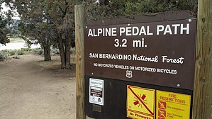
This asphalt path meanders along the sparkling north shore of Big Bear Lake from Stanfield Cutoff to the Solar Observatory and Serrano Campground. Although not flat by any means, its’ ups and downs are fairly gentle. In the fall of 1998 the path was extended and includes a pedestrian tunnel under Hwy 38 to the Cougar Crest Trail parking lot. The new extension continues east 0.6 of a mile and connects with the Big Bear Discovery Center.


Hikers can find water, restrooms and expert advice on all varieties of recreation in the San Bernardino National Forest at the Discovery Center. Seasonal parking is also available at Juniper Point Picnic Area and Meadow’s Edge Picnic Area with an Adventure Pass or Interagency Pass.

2018-07-14 HAZ_Hikebot


    Check out the Official Route and Triplogs.
    Leave No Trace and +Add a Triplog after your hike to support this local community.

    One-Way Notice
    This hike is listed as One-Way.

    When hiking several trails on a single "hike", log it with a generic name that describes the hike. Then link the trails traveled, check out the example.
    WARNING! Hiking and outdoor related sports can be dangerous. Be responsible and prepare for the trip. Study the area you are entering and plan accordingly. Dress for the current and unexpected weather changes. Take plenty of water. Never go alone. Make an itinerary with your plan(s), route(s), destination(s) and expected return time. Give your itinerary to trusted family and/or friends.

     Permit $$
    no fees or permits reported

    if incorrect tell us about it

    San Bernadino Forest
    Visit the San Bernadino Passes & Permits for current information


     Directions
    or
     Road


    To hike
    page created by joebartels on Jul 29 2015 7:27 pm
     90+° 8am - 6pm kills
    helpcorrectionissue

    end of page marker