 Route Editor

| Guide | ♦ | 2 Triplogs | 0 Topics |
details | drive | no permit | forecast | 🔥 route |
stats |
photos | triplogs | topics | location |
| 0 | 2 | 0 |
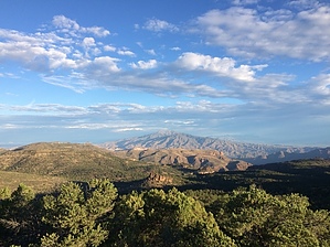
  Boulder Peak is an easy to reach peak via Reavis Ranch and the Reavis Gap Trail. It can be reached from Boulder Pass and requires about a two-tenths of a mile off-trail climb from the Reavis Gap Trail. There are some nice 360 degree views from the summit highlighted by Four Peaks to the north and a benchmark from 1946. Boulder Peak would make a great quick day trip option if staying at the ranch. Boulder Peak is an easy to reach peak via Reavis Ranch and the Reavis Gap Trail. It can be reached from Boulder Pass and requires about a two-tenths of a mile off-trail climb from the Reavis Gap Trail. There are some nice 360 degree views from the summit highlighted by Four Peaks to the north and a benchmark from 1946. Boulder Peak would make a great quick day trip option if staying at the ranch.Check out the Official Route and Triplogs. Note This is a moderately difficult hike. Leave No Trace and +Add a Triplog after your hike to support this local community. One-Way Notice This hike is listed as One-Way. When hiking several trails on a single "hike", log it with a generic name that describes the hike. Then link the trails traveled, check out the example. | |||||||||||||||||||||||||||||||||||||||||||||||||||||||||||||||||||||||||||||||||||||


