Route Editor

| Guide | ♦ | 68 Triplogs | 3 Topics |
details | drive | no permit | forecast | 🔥 route |
stats |
photos | triplogs | topics | location |
| 755 | 68 | 3 |
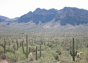
Easy, but scratchy solitude by nealz  Here's a nice out-and-back hike and a good way to get out to the Western Superstitions without running into a lot of other hikers. It was a tad warmer than I like in mid-October, but not unbearable. Here's a nice out-and-back hike and a good way to get out to the Western Superstitions without running into a lot of other hikers. It was a tad warmer than I like in mid-October, but not unbearable.You start at the hugely popular Peralta Trailhead parking lot, pay your fee, and then head east on Dutchman Trail #104. The trail climbs quickly from the parking lot and soon you'll crest the saddle, leave the trailhead view behind, and look over the scenic Barkley Basin. The trail easily switchbacks down to the basin floor and meanders across the northern edge of Barkley Basin. You can see Miner's Needle from any point along this part of the trail. To the south is the broad, flat plain of the basin which lies in both the Tonto NF and the privately held Quarter Circle U Ranch. I was surprised at how lush this part of the Supers was at the end of another blast-furnace summer. I would guess it's due largely to a good Monsoon.
The trail dips in and out of some arroyos and becomes just slightly more rugged than the previous Dutchman's Trail. Soon you'll slowly switchback up to another junction with a connector trail from the Quarter Circle U. This section of the Coffee Flat Trail used to be part of an old freight wagon road that led from Mesa to Superior during the late 1890s and early 1900s. It's interesting to imagine someone driving a mule wagon through this landscape. Stay on the Coffee Flat continuing east. The Coffee Flat Mountains make an informal U shape seen to the north. The trail continues down from the ranch junction to Whitlow Canyon and some cool shade in the Mesquite bosques. Along the trail to the south, there is an old corral that makes an interesting rest spot. Continue on the Coffee Flat about another mile to Coffee Flat proper. You'll know you're close when you spot the bright green, as I write this, Cottonwoods that are down along Coffee Flat Creek. Cottonwoods are real water-hogs and they're a good indicator of either surface water or water near the surface in the Sonoran Desert. You'll see the trees and an old windmill below you at the base of Buzzard's Roost, a tall stand of orange rock that colorfully backgrounds this spot. The trail travels down to the creekbed, dry right now but with plenty of high-water debris, and crosses up to the largest multi-armed saguaro I have ever seen. Take the side trail to the windmill and stock tank. There is usually filterable or treatable water in the tank to replenish your supply and it makes for a refreshing head-dunk if it's a warm day. Plan to spend some time here as the water supply that creates this oasis of Willow and Cottonwood is really pleasant. You can turn around here and head back to Peralta for a round trip of about 10.6 miles or you can continue to Dripping Springs. To Dripping Springs, take the trail south towards Buzzard's Roost and you'll soon come to a stick and barb wire fence and gate. The trail continues past the gate into the private land of the Quarter Circle U Ranch for about 3/4 mile, then back into the Tonto NF. Ranch and range etiquette rules apply here. If the gate is open, pass through and leave it open. If it is closed, pass through and re-close it after you. The trail, as it passes into private land, is not maintained by the Forest Service and it can get a little difficult to follow and is quite overgrown with plenty of Catclaw in spots. My legs look like pincushions in boots today. Long pants are a great idea. At the base of Buzzard's Roost, turn left or east to continue. The trail sort of follows Randolph Canyon and you'll need to tune up your trail finding skills a little. Watch closely for cairns marking the crossings at washes and mind the Catclaw. After the trail returns to Tonto NF land, things get better. Continue for another 3/4 mile along, and in, Randolph Canyon. Again look for the telltale Cottonwoods that mark Dripping Springs. This is another great spot. Flat rocks and some water in the creekbed and nice shade, and sound, from the Cottonwoods in the wind. The spring is on the south side of the canyon and drips from a fissure in the wall. There are several sweet campsites here so I'd like to backpack in some time and spend a night or two. Rest and water up and then head back the way you came to the Peralta Trailhead. Gate Policy: If a gate is closed upon arrival, leave it closed after you go through. If it is open, leave it open. Leaving a closed gate open may put cattle in danger. Closing an open gate may cut them off from water. Please be respectful, leave gates as found. The exception is signage on the gate directing you otherwise. Check out the Official Route and Triplogs. Leave No Trace and +Add a Triplog after your hike to support this local community. | |||||||||||||||||||||||||||||||||||||||||||||||||||||||||||||||||||||||||||||||||||||||||||||||||||||||||||||||||||||||||||||||||||||||||||||||||||||||||||||||||||||||||||||||||||||||||||||||||||||||||