 Route Editor

| Guide | ♦ | 5 Triplogs | 0 Topics |
details | drive | permit | forecast | route |
stats |
photos | triplogs | topics | location |
| 10 | 5 | 0 |
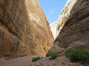
Wind your way through the park by iheartmonster  Starting out at the trailhead off of UT-24, you will see a trail heading down next to the rocks under wire mesh put in place for flood control. Follow the trail into the wash and your journey into the canyon begins. Along the way, you will follow the sandstone walls of the canyon. The walls are lined with several small arches, pothole arches, and other interesting featres along the way. There are caves and boulders and holes to explore.
Grand Wash winds its way through the park, ending up at the Cassidy Arch Trailhead and the Grand Wash road. The trail ends at Cassidy Arch Trailhead, but this trailhead is not easy to see. Once you get used to walking through the canyon and looking up along the way, you may miss the sign that is at ground level and made of sandstone, blending very well into its surroundings. Start looking for it on your right at the 2 mile mark. Some GPS units will not be accurate as the walls in the canyon will interfere. Grand Wash is the only way to the Cassidy Arch trail, so you may see others along the way start to ascend that trail. This is your cue to turn around, or start the 1150 foot ascent up that trail. This trail does not allow dogs or mountain bikes as they are explicitly forbidden by signage at the trailhead. Flash floods are of concern when hiking this trail, so be aware of your surroundings and your surrounding weather. Even though there may be blue skies ahead, you can still encounter a flash flood if the rain is on its way to the Fremont River which is just across the road from the trailhead; this wash is a major drainage for the entire area. The signage says that the water can get to 15' deep in a matter of minutes. Flash flood season is late summer to early fall, but that does not mean that these warnings are not to be heeded the rest of the year. There is a good stretch of this trail that does not have anything available for you to climb to get out of the water. Be smart. Capitol Reef encompasses a very arid climate. Even though the walls of the canyon afford some shade, use sunscreen and drink plenty of water, even in the cooler months. There are no facilities at the trailhead. The trailhead does not fall within the fee area of Capitol Reef National Park and does not require any permit to hike.
Check out the Official Route and Triplogs. Leave No Trace and +Add a Triplog after your hike to support this local community. One-Way Notice This hike is listed as One-Way. When hiking several trails on a single "hike", log it with a generic name that describes the hike. Then link the trails traveled, check out the example. | ||||||||||||||||||||||||||||||||||||||||||||||||||||||||||||||||||||||||


