Route Editor

| Guide | ♦ | 4 Triplogs | 0 Topics |
details | drive | no permit | forecast | route |
stats |
photos | triplogs | topics | location |
| 26 | 4 | 0 |
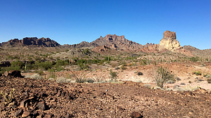
Thumb your nose at the big eye by chumley  Thumb Peak is the second-highest peak in the Castle Dome Mountains and offers excellent views across the entire range and distant views across the entire Kofa NWR and much of southwest Arizona. Thumb Peak is the second-highest peak in the Castle Dome Mountains and offers excellent views across the entire range and distant views across the entire Kofa NWR and much of southwest Arizona.Getting to the hike likely takes longer than the hike itself. Check drive directions for details.
You may find more success staying out of the drainage, but the side-hill footing can get annoying. Dropping into the drainage is a more direct fall-line climb, but features more brush and occasional catclaw. Pick your poison. After about 3/4 mile and climbing about 600 feet, you will turn sharply to the left and climb a very steep slope directly to a notch in the ridge. The very imposing cliff face below the summit will be on your left. There is a small spire on the ridge, and you should aim for the obvious notch to the left of it. This section climbs 500 feet over a quarter-mile. Once on the ridge, cross over to the east side and traverse along the slope to the northeast corner of the peak, where you can scramble the final 100 feet to the summit. There is a short 10-foot climb that some may consider an easy class-4. Exposure is minimal, and if you've made it this far, the climb should be no problem for you. Once on the summit, enjoy the views, sign the register, and head back the way you came. Check out the Official Route and Triplogs. Note This is a moderately difficult hike. Leave No Trace and +Add a Triplog after your hike to support this local community. | |||||||||||||||||||||||||||||||||||||||||||||||||||||||||||||||||||||||||||||||||||||||||||||||||||