Route Editor

| Guide | ♦ | 1 Triplog | 0 Topics |
details | drive | permit | forecast | route |
stats |
photos | triplog | topics | location |
| 34 | 1 | 0 |
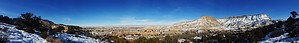
Redrock Sampler by PaleoRob  Warning: The trail can be icy during the winter. In the summer, canyon walls can reflect the day's heat, making the canyon an oven. The seasonal stream is not considered to be safe for drinking, according to Colorado National Monument guidelines.
Hike: The hike starts out from the Devil's Kitchen trailhead and follows the Old Gordon Trail, a historic toll road into the monument, for about half of its length. The trail descends from the parking area and soon comes to a fork. This is about a tenth of a mile into the hike. There is a sign at the fork for Echo Canyon/Old Gordon Trail. Follow the arrows to the left. The trail continues to descend towards the wash at the mouth of No Thoroughfare Canyon. The big, unnamed point of Morrison, Peak 5513, is prominent in front of you. Two posts, one on either side of the wash, mark the trail where it crosses the watercourse. On the far side there's a sign indicating that you are on the correct path for the Echo Canyon/Old Gordon trail. From this point the trail begins to rise and curve to the south. After ascending 189 feet in a quarter mile, you come to where the Old Gordon trail diverges. The Echo Canyon trail heads back downhill at this point. It is obvious why you have to get up to get down on the Echo Canyon trail; the confluence of Echo Canyon's creek and No Thoroughfare lies on private land. The trail skirts the property boundary and several houses can be seen from this section of the trail. You lose all the elevation you just gained in the quarter mile descent that brings you to the bottom of Echo Canyon. From this point the hike becomes a classic Colorado Plateau canyon hike. You move along through the wash bottom, occasionally climbing streamside terraces to get better views of the soaring red walls. There are also some short slots in the stream course that you skirt on slickrock ledges. Nothing technical or challenging, but classic desert southwest hiking all the same. Eventually you will come to a huge double-layer alcove in the Entrada sandstone on your right hand (west) side. This short drainage and the cliff marks the usual end-point of the hike. While it is possible to continue in the streambed, the monument boundary is around the next bend in the canyon and the trail can be a bit muddy from this point on out. Once you've seen all you care to see, retrace your steps back to the parking lot. Depending on upstream permissions, it may be possible to use this trail as a start to an up-canyon backpacking trip. Water Sources: A seasonal creek runs through Echo Canyon but the NPS cautions against using any water sources in the monument. Bring your own. Camping: Backcountry camping is possible in the monument. With the hike being so short, however, it probably doesn't get camped in at all. Check out the Official Route and Triplog. Leave No Trace and +Add a Triplog after your hike to support this local community. | |||||||||||||||||||||||||||||||||||||||||||||||||||||||||||||||||||||||||||||||||||||||||