Note
This description needs a rewrite as the full spur from the loop of the Maricopa Trail.
Parked at the Bulldog Canyon Usery Pass TH. The entrance to the new Maricopa County Trail - Usery Spur is located at the southeast corner of the dirt parking lot. I try to stay away from parking on the northeast side due to the number of nails that I have found due to people bringing pallets out and burning them for campfires.
This trail is smooth and mostly free of rocks. It's a great trail for bikes and trail runners. I went up to the intersection of the Pass Mountain Loop Trail and turned around. This would make a great route up to Pass Mountain Saddle. Then return to get some miles in and forget about the rocks on the South and East side of Pass Mountain Loop Trail. Will be interesting when they complete the whole Maricopa Trail Loop totaling 242 miles. Maybe I should get a head start and hike the trails that they have finished, would be a good project.
When hiking several trails on a single "hike", log it with a generic name that describes the hike. Then link the trails traveled, check out the example.
WARNING! Hiking and outdoor related sports can be dangerous. Be responsible and prepare for the trip. Study the area you are entering and plan accordingly. Dress for the current and unexpected weather changes. Take plenty of water. Never go alone. Make an itinerary with your plan(s), route(s), destination(s) and expected return time. Give your itinerary to trusted family and/or friends.
Permit $$
None
Directions
Road
Paved - Car Okay
To Lone Mountain Trailhead Located on the east side of Usery Pass Road. It is 1.7 miles north of the Usery Mountain Regional Park main entrance and 2.8 miles south of Bush Highway. Parking is free, and a Tonto Pass is NOT required for hiking.
It is also an access point for the Tonto National Forest OHV area - Usery Gate for Road 3554. There is a gate to restrict motorized travel on the road but there is a hiking-in gate. If you want to drive this road you can get a free permit at the Mesa Ranger Station. The permit provides you with the combination to the lock.
From PHX (I-10 & AZ-51) - 33 min (31.5 miles) From TUC (Jct 1-10 & Grant) - 1 hr 58 min (118 miles) From FLG (Jct I-17 & I-40) - 2 hr 29 min (175 miles)
 Route Editor

 Note
Note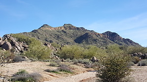


