Route Editor

| Guide | ♦ | 2 Triplogs | 0 Topics |
details | drive | permit | forecast | map |
stats |
photos | triplogs | topics | location |
| 14 | 2 | 0 |
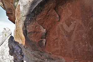
Exactly what is on the box. by PaleoRob  Warning: There is no water and little shade on this route. Bring your own water and plan your departure time appropriate to the weather conditions.
Hike: Starting from the White Rocks trailhead on South Broadway, turn left on the obvious trail. It isn't marked by a sign or on the map at the trailhead, but it follows an obvious straight rise towards the east. The collection of white boulders, White Rocks, will now be directly ahead of you and is your target. Several social trails branch out as you approach White Rocks, but the official trail is relatively easy to stay on - the largest and most worn of the trails. You can either go left or right at the main trail junction as this is a lasso loop - the trail will return you to the small stand of junipers where the trails split. There are two main petroglyph panels along the trail. Neither is very large and both have suffered substantial vandalism. As a result, White Rocks is now closed overnight, so no camping in the area is allowed. If you have a hard time finding the petroglyphs, look for the carsonite posts with signage about protecting our cultural heritage. The trail winds around the east side of White Rocks. There are numerous social trails that criss-cross the boulders but it is also impossible to get lost. To the north is Colorado 340. To the south is The Bench, a massive outcrop of black Precambrian schist and gneiss. To the west, at this point, is White Rocks. Simply head north if you get off trail and find the well traveled main trail. This will take you by the monument boundary and then between two boulders. From there you have a great vantage point to the west. The red Mesozoic rocks have been bent and tilted, a testament to the forces involved in the Redlands Fault and the uplift of the Uncompahgre Plateau. From there, follow the trail back down to the junction and head back towards the parking area. Water Sources: None, bring all you need. Camping: The White Rocks area is closed from 30 minutes before sunrise to 30 minutes after sunset. No camping is allowed in the White Rocks area. Check out the Triplogs. Leave No Trace and +Add a Triplog after your hike to support this local community. | ||||||||||||||||||||||||||||||||||||||||||||||||||||||||||||||||||||||||||||||||||||||||||