username
X
password
register
for free!
help
  

Mescal Trail - Sedona, AZ

Guide 23 Triplogs  1 Topic
  4.1 of 5  
Fav
Wish
0
details
drive
permit
forecast
route  
stats
photos
triplogs
topic
location
244 23 1
Statistics
tap row or icons for details
Difficulty 1 of 5
Distance One Way 2.57 miles
Trailhead Elevation 4,492 feet
Elevation Gain 154 feet
Accumulated Gain 206 feet
Kokopelli Seeds 3.26
unreported if dogs are allowed
editedit > ops > dogs to adjust
feature photo
Photos Viewed All MineFollowing
Will recalculate on button tap!
12  2023-02-10 tibber
25  2022-04-27
Mescal Mountain Loop
LosDosSloFolks
36  2022-04-27
Mescal Mountain Loop
tibber
5  2021-12-10 toddak
6  2021-04-22
Mescal Chuck Wagon Loop
Nightstalker
5  2020-05-23
Mescal Chuck Wagon Loop
Nightstalker
24  2019-06-23
Mescal Mountain Loop
tibber
11  2019-04-20
Chuckwagon - Mescal - Deadman's pass - Long Ca
cw50must
Page 1,  2
Author
author avatar Guides 16,843
Routes 17,472
Photos 24
Trips 1 map ( 6 miles )
Age 28 Male Gender
Location HAZ, TrailDEX
Associated Areas
list map done
Sedona Region
Historical Weather
Trailhead Forecast
Radar Map
Expand Map
Preferred Mar, Nov, Apr, Feb
Sun  6:02am - 6:50pm
Official Route & 2 Rts
 
10 Alternative


remove free decal offer

Guide Needed
Publish Full Detail Guide


Use +Add above to share photos and triplogs
Mescal Trail runs from Long Canyon Trail on the NW terminus to Chuckwagon Trail on the SE terminus. There is a trailhead where Mescal crosses Long Canyon Road ( paved ) a quarter mile up from the SE end.
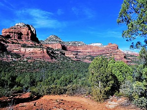


  • 2021 Verde Valley Trails
    region related
    2021 Verde Valley Trails
  • 2021 Verde Valley Area
    region related
    2021 Verde Valley Area
  • 2021 Sedona Trails Map
    region related
    2021 Sedona Trails Map


Check out the Official Route and Triplogs.
Leave No Trace and +Add a Triplog after your hike to support this local community.

One-Way Notice
This hike is listed as One-Way.

When hiking several trails on a single "hike", log it with a generic name that describes the hike. Then link the trails traveled, check out the example.
WARNING! Hiking and outdoor related sports can be dangerous. Be responsible and prepare for the trip. Study the area you are entering and plan accordingly. Dress for the current and unexpected weather changes. Take plenty of water. Never go alone. Make an itinerary with your plan(s), route(s), destination(s) and expected return time. Give your itinerary to trusted family and/or friends.

 Permit $$
Red Rock Pass - may or may not be required. Go to Red Rock Pass then check "When is a Red Rock Pass Required?". If you have questions contact the Coconino forest service.


 Directions
or
 Road
Paved - Car Okay

To hike
page created by joebartels on Feb 10 2016 5:56 pm
 90+° 8am - 6pm kills
helpcorrectionissue

end of page marker