Route Editor

| Guide | ♦ | 3 Triplogs | 0 Topics |
details | drive | permit | forecast | map |
stats |
photos | triplogs | topics | location |
| 23 | 3 | 0 |
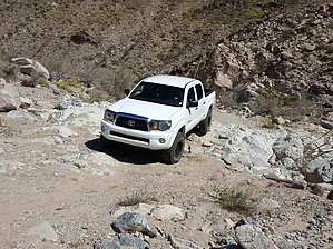
A Back Country Road in JT by cw50must  The road begins directly across from the Cottonwood visitors center near the south entrance of the park off I-10. Its a dirt road marked by a "4wd required" yellow sign. There is also an information sign explaining the history and sites along with a map. The first section is 7 miles until you enter Pinkham Canyon, its 20 miles total from the start to I-10, you can also choose to take the BLM road that parallels I-10 back to the park entrance. I chose this route as it keeps you on all dirt for a nice 30 mile loop. If you bring the BLM road back you can also scope out some of the campsites available outside the park. While in Pinkham canyon you have the option to include Thermal canyon as well, this would add extra miles and could also be a way to do a lollipop loop and come back the way you came. Lots of options.
Check out the Triplogs. Leave No Trace and +Add a Triplog after your 4x4 trip to support this local community. | ||||||||||||||||||||||||||||||||||||||||||||||||||||||||||||||||||||||||||