 Route Editor

| Guide | ♦ | 9 Triplogs | 0 Topics |
details | drive | no permit | forecast | route |
stats |
photos | triplogs | topics | location |
| 4 | 9 | 0 |
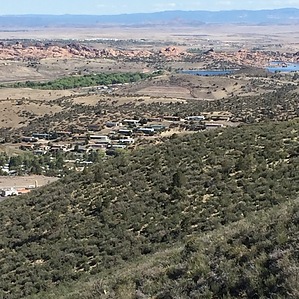
Where's the "P" by MEWhiteman   Overview OverviewThe Badger Mountain Trail (aka P-Mountain Trail) is part of the Prescott Circle Trail and connects the Turley Trail to the Sundog Trail at AZ69. It goes over the shoulder of Badger Mountain with views of the “P” as you hike. However, you don’t pass very near this landmark. It is a smooth, well-graded, easy to follow, single-track trail with very little shade for use by non-motorized travel. There are some lovely views to the north, including Granite Mountain and Watson Lake. This hike may be done as an out and back or a shuttle hike when combined with the Sundog Trail. Hike I’ve described this from the Turley Trailhead to AZ69. Beginning at the Turley Trailhead, hike 0.17 miles to the junction with the Badger Mountain Trail at N34 32.351 W112 26.289. Turn left and begin a gradual ascent. At 1.13 miles from the trailhead (N34 32.444 W112 25.857), cross a dirt road which I assume provides access to the towers at the top. A short distance further, there is a metal bench that marks the high point of this trail and provides a nice spot to take in the views. Begin a gradual descent following the curves of the mountain, reaching the culvert under AZ69 at 4.29 miles (N34 33.117 W112 25.019) which marks the end of this trail and the beginning of the Sundog Trail. There is no parking at this end. Check out the Official Route and Triplogs. Leave No Trace and +Add a Triplog after your hike to support this local community. One-Way Notice This hike is listed as One-Way. When hiking several trails on a single "hike", log it with a generic name that describes the hike. Then link the trails traveled, check out the example. | ||||||||||||||||||||||||||||||||||||||||||||||||||||||||||||||||||||||||||||||||||||||||||||||||||||||||||||||||||||||||||||||||||||||||||||||||||||||||||||||||||||||||||||||||||


