Route Editor

| Guide | ♦ | 12 Triplogs | 0 Topics |
details | drive | permit | forecast | route |
stats |
photos | triplogs | topics | location |
| 60 | 12 | 0 |
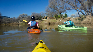
Whatever floats your boat by chumley   Overview OverviewThis 10-mile section of the Verde River is amongst the most popular for an easy half-day paddle. Access is simple, and setting up a return shuttle takes about half an hour. River Access The put-in is at the White Bridge River Access Point, where Highway 260 crosses the Verde River. There is a developed site here with parking, pit toilets, and a graded walkway to the river at the base of the bridge. (Note the original White Bridge is long gone, replaced by the current bridge in 1982).
The exit at Beasley Flat is shortly after passing the prominent white gypsum cliffs on the east side of the river. You will see picnic tables on the hillside well ahead of when you should exit. Wait until you can see the actual road cut where it comes down to the river. There is a small wooden dock extending from the shore to provide a less-muddy exit option. Beasley Flat also has pit toilets and ample parking for your shuttle vehicle. Description White Bridge is at river mile 39.5 on the Verde River Paddle Trail Guide published by the Coconino National Forest. It's an excellent review of the entire river trip and highly recommended for reading. Most of the river consists of flat water with a light flow. There are short stretches of riffles and a couple of short stretches that might reach class 2 at some flow levels. Most novice paddlers with some previous experience should feel comfortable making this trip. The river flows through stretches of wilderness, thick with shady trees and replete with numerous species of birds. In other stretches, the river flows through the vast yards of beautiful homes along the river banks. Enjoy the scenery as you pass through this picturesque slice of the Verde Valley. Highlights Around mile 43.5, the flow from an irrigation canal flows into the river from the left. At river mile 44, you will pass an erosion project on the right bank, protecting the precarious structures on the bank high above the river. At mile 45, you reach the Clear Creek RAP, including a concrete dam on river right that makes a quick-moving channel on the left. Half a mile later, you will pass West Clear Creek's confluence in a shallow section of the river. It's easy to miss if you're not looking for it! At about mile 46.5, the river turns sharply south when reaching the gypsum cliffs, followed shortly by a narrow shaded section. At 47.5, the river turns east again and passes through a couple of fast sections of riffles. Beasley Flat is visible on the right, but you'll want to continue downstream around the peninsula it consists of. The river turns south again at 48.5 and continues about a mile directly next to gypsum cliffs before reaching the exit point. River Flow The Forest Service uses 100 CFS as the indicator of "low flow". They report that under 50cfs makes the trip difficult. We did this trip in 4 hours with a 225 CFS flow. I'm not sure what maximum flow would be appropriate for this trip, but 100 seems to be a good minimum. The FS recommends not paddling the river during flood. Current flow reading can be found by the USGS gauging station below Beasley Flat ( link here ) Check out the Official Route and Triplogs. Leave No Trace and +Add a Triplog after your kayak trip to support this local community. | ||||||||||||||||||||||||||||||||||||||||||||||||||||||||||||||||||||||||||||||||||||||