username
X
password
register
for free!
help
  

Grandstaff Canyon, UT

Guide 6 Triplogs  0 Topics
  4.2 of 5  
Fav
Wish
4
details
drive
permit
forecast
route  
stats
photos
triplogs
topics
location
22 6 0
Statistics
tap row or icons for details
Difficulty 1.5 of 5
Route Finding 1 of 5
Distance One Way 2.3 miles
Trailhead Elevation 3,993 feet
Elevation Gain 318 feet
Accumulated Gain 418 feet
Kokopelli Seeds 3.69
 Interest Perennial Creek
feature photo
Photos Viewed All MineFollowing
17  2021-04-25 azbackpackr
5  2016-04-19 trekkin_gecko
Author
author avatar Guides 10
Routes 673
Photos 7,281
Trips 4,660 map ( 39,011 miles )
Age 67 Female Gender
Location phoenix, az
Co-Author
co-author avatarGuides 16,843
Routes 17,472
Photos 24
Trips 1 map (6 Miles)
Age 28 Male Gender
Location HAZ, TrailDEX
Associated Areas
list map done
Southeast Region
Historical Weather
Trailhead Forecast
Radar Map
Expand Map
Preferred Mar, Apr, Oct, Nov
Sun  5:51am - 6:42pm
Official Route & 2 Rts
 
0 Alternative


gentle canyon, babbling brook, singing birds
by trekkin_gecko & HAZ_Hikebot

History
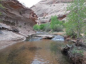
The canyon was named after William Grandstaff, a mixed-race cowboy who prospected and ran cattle in the desert canyon in the late 1870s with a Canadian trapper named Frenchie. They took joint possession of the abandoned Elk Mountain Mission fort near Moab after 1877, and each controlled part of the Spanish Valley. Grandstaff fled the area in 1881 after being charged with bootlegging whiskey to the Indians.


Hike
Grandstaff Canyon follows a perennial stream that drains into the Colorado River. The trail, shaded by cottonwood and willow trees, stays near the creek for 1.85 miles, then ascends a canyon wall and ends under Morning Glory natural bridge.
remove free decal offer
Family and dog friendly, it's an easy trek until the short climb. The natural bridge is a fabulous destination and a good place for a snack. It has a span of 243 feet, which is the 6th longest span in the U.S., according to BLM statistics. Watch for poison ivy growing under the bridge.

BLM land access is complimentary.

Sources
trekkin_gecko, Wikipedia, azbackpackr, John9L


    Check out the Official Route and Triplogs.
    Leave No Trace and +Add a Triplog after your hike to support this local community.

    One-Way Notice
    This hike is listed as One-Way.

    When hiking several trails on a single "hike", log it with a generic name that describes the hike. Then link the trails traveled, check out the example.
    WARNING! Hiking and outdoor related sports can be dangerous. Be responsible and prepare for the trip. Study the area you are entering and plan accordingly. Dress for the current and unexpected weather changes. Take plenty of water. Never go alone. Make an itinerary with your plan(s), route(s), destination(s) and expected return time. Give your itinerary to trusted family and/or friends.

     Permit $$

     Directions
    or
     Road
    Paved - Car Okay

    To hike
    from moab, leave 191 at intersection with 128 and go three miles east
    trailhead is on the right
    limited parking, but more available just up 128 on the left
    page created by trekkin_gecko on Apr 24 2016 9:03 am
     90+° 8am - 6pm kills
    helpcorrectionissue

    end of page marker