 Route Editor

| Guide | ♦ | 28 Triplogs | 0 Topics |
details | drive | permit | forecast | route |
stats |
photos | triplogs | topics | location |
| 244 | 28 | 0 |
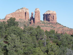
Not That Shady by HAZardous   Overview OverviewThis south Sedona area trail connects the Village of Oak Creek (VOC) to the Templeton trail at the HT Trail junction. It travels between the SR-179 on the east, and the Transept on the west, gradually ascending to Yavapai Vista, then descending. Frequently used by bicyclists who stay in, or rent their bikes in the VOC, though I saw only one bike vs. half a dozen hikers the summer Saturday morning I hiked it for this description. I expect more traffic during cooler weather. Hike From the south, Slim Shady starts at the north end of the paved sidewalk on the west side of 179 in the VOC. It can also be accessed directly across 179 from the Bell Rock Vista sign (entrance to the Red Rock fee parking area south of Bell Rock) or through the Red Agave Resort off Canyon Circle Drive (be courteous to guests, walk your bike if riding.) After crossing over a drainage culvert, the trail heads off 179 and northwest into a wash. After about 200 yards you meet the junction that goes to Canyon Circle Drive, then another 300 yards is the south junction of the Made in the Shade trail. Continuing to climb slightly, the trail undulates across washes as it makes its way north through typical Sedona vegetation including juniper, scrub oak, manzanita, yucca, prickly pear, and catclaw. You might spot the occasional cottontail, javelina or coyote. Good views of Bell Rock and Courthouse Butte pop up along the way.
Check out the Official Route and Triplogs. Leave No Trace and +Add a Triplog after your hike to support this local community. One-Way Notice This hike is listed as One-Way. When hiking several trails on a single "hike", log it with a generic name that describes the hike. Then link the trails traveled, check out the example. | ||||||||||||||||||||||||||||||||||||||||||||||||||||||||||||||||||||||||||||||||||||||||||||||||||||||||||||||||||||||||||||||||||||||||||||||||||||||||||||||||||||||||||||||||||||||||||||||


