 Route Editor

| Guide | ♦ | 1 Triplog | 0 Topics |
details | drive | permit | forecast | route |
stats |
photos | triplog | topics | location |
| 14 | 1 | 0 |
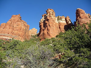
A higher shade of red by HAZardous   Overview OverviewMade in the Shade is a south Sedona area trail located just north of the Village of Oak Creek (VOC). It starts and ends on the Slim Shady Trail, and provides a longer section, at a higher elevation, with a better view than hiking Slim Shady straight through. It gets shaded from the Transept slightly earlier in the afternoon as well (not much, really.) Hike To get to Made in the Shade, you first have to hike the Slim Shady Trail to one of the trail junctions. This description is from the north junction. The trail ascends through typical Sedona flora, including scrub oak, juniper, yucca, prickly pear. It first switchbacks its way up the Transept. Looking back, you have the closest elevated view of Bell Rock available. The trail heads south across a rounded slickrock ridge, not scary unless you are particularly sensitive to heights. The trail continues up into a drainage where it winds through some large boulders. The trail then levels out, continuing south with views of the VOC and Horse Mesa behind it. There are endless views of Bell Rock, Courthouse Butte, and Twin Peaks to the east and north. The trail descends slowly to a slickrock platform. Castle Rock, the southernmost formation of the Transept, is visible to the west. Route finding here is a bit tricky. Look for blue or white paint marks and check the margins of slickrock patches for bicycle tracks as you descend. The trail drops from the slickrock area through a wash, down to the south junction with Slim Shady.
Check out the Official Route and Triplog. Leave No Trace and +Add a Triplog after your hike to support this local community. One-Way Notice This hike is listed as One-Way. When hiking several trails on a single "hike", log it with a generic name that describes the hike. Then link the trails traveled, check out the example. | |||||||||||||||||||||||||||||||||||||||||||||||||||||||||||||||||||||||||||||||||||||||||


